You are here: Home > Network List > TJ - Tajikistan National Seismic Network Stations List
> Station GARM Garm, Tajikistan > Earthquake Result Viewer
GARM Garm, Tajikistan - Earthquake Result Viewer
| Earthquake location: |
Sumba Region, Indonesia |
| Earthquake latitude/longitude: |
-10.5/120.1 |
| Earthquake time(UTC): |
2018/10/02 (275) 04:49:31 GMT |
| Earthquake Depth: |
21 km |
| Earthquake Magnitude: |
5.6 Mww |
| Earthquake Catalog/Contributor: |
NEIC PDE/us |
|
| Network: |
TJ Tajikistan National Seismic Network |
| Station: |
GARM Garm, Tajikistan |
| Lat/Lon: |
39.00 N/70.32 E |
| Elevation: |
1305 m |
|
| Distance: |
67.6 deg |
| Az: |
319.919 deg |
| Baz: |
125.637 deg |
| Ray Param: |
0.056842398 |
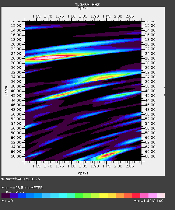
| Estimated Moho Depth: |
25.5 km |
| Estimated Crust Vp/Vs: |
1.70 |
| Assumed Crust Vp: |
6.306 km/s |
| Estimated Crust Vs: |
3.715 km/s |
| Estimated Crust Poisson's Ratio: |
0.23 |
|
| Radial Match: |
83.508125 % |
| Radial Bump: |
400 |
| Transverse Match: |
68.299995 % |
| Transverse Bump: |
400 |
| SOD ConfigId: |
13570011 |
| Insert Time: |
2019-05-01 09:36:07.925 +0000 |
| GWidth: |
2.5 |
| Max Bumps: |
400 |
| Tol: |
0.001 |
|
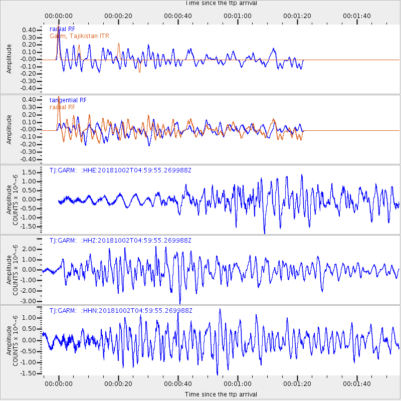
Signal To Noise
| Channel | StoN | STA | LTA |
| TJ:GARM: :HHZ:20181002T04:59:55.269988Z | 3.7186542 | 6.1608955E-7 | 1.656754E-7 |
| TJ:GARM: :HHN:20181002T04:59:55.269988Z | 1.0180838 | 1.6742699E-7 | 1.6445306E-7 |
| TJ:GARM: :HHE:20181002T04:59:55.269988Z | 1.3485096 | 2.1879755E-7 | 1.622514E-7 |
| Arrivals |
| Ps | 2.9 SECOND |
| PpPs | 10 SECOND |
| PsPs/PpSs | 13 SECOND |


