You are here: Home > Network List > TA - USArray Transportable Network (new EarthScope stations) Stations List
> Station U18A Rough Rock, Chinle, AZ, USA > Earthquake Result Viewer
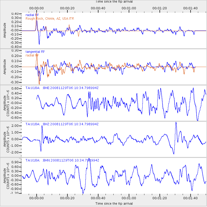
U18A Rough Rock, Chinle, AZ, USA - Earthquake Result Viewer
*The percent match for this event was below the threshold and hence no stack was calculated.
| Earthquake location: |
Fiji Islands Region |
| Earthquake latitude/longitude: |
-18.7/-177.7 |
| Earthquake time(UTC): |
2008/11/29 (334) 05:59:16 GMT |
| Earthquake Depth: |
386 km |
| Earthquake Magnitude: |
5.7 MB, 6.0 MW, 5.9 MW |
| Earthquake Catalog/Contributor: |
WHDF/NEIC |
|
| Network: |
TA USArray Transportable Network (new EarthScope stations) |
| Station: |
U18A Rough Rock, Chinle, AZ, USA |
| Lat/Lon: |
36.42 N/109.87 W |
| Elevation: |
1878 m |
|
| Distance: |
84.3 deg |
| Az: |
48.66 deg |
| Baz: |
241.92 deg |
| Ray Param: |
$rayparam |
*The percent match for this event was below the threshold and hence was not used in the summary stack. |
|
| Radial Match: |
60.754814 % |
| Radial Bump: |
400 |
| Transverse Match: |
65.8009 % |
| Transverse Bump: |
363 |
| SOD ConfigId: |
2658 |
| Insert Time: |
2010-03-06 16:25:36.384 +0000 |
| GWidth: |
2.5 |
| Max Bumps: |
400 |
| Tol: |
0.001 |
|
Signal To Noise
| Channel | StoN | STA | LTA |
| TA:U18A: :BHZ:20081129T06:10:34.798994Z | 3.0501351 | 8.0079207E-7 | 2.6254315E-7 |
| TA:U18A: :BHN:20081129T06:10:34.798994Z | 1.5072714 | 2.499498E-7 | 1.6582932E-7 |
| TA:U18A: :BHE:20081129T06:10:34.798994Z | 1.1994163 | 2.3523741E-7 | 1.9612658E-7 |
| Arrivals |
| Ps | |
| PpPs | |
| PsPs/PpSs | |


