You are here: Home > Network List > US - United States National Seismic Network Stations List
> Station HAWA Hanford, Washington, USA > Earthquake Result Viewer
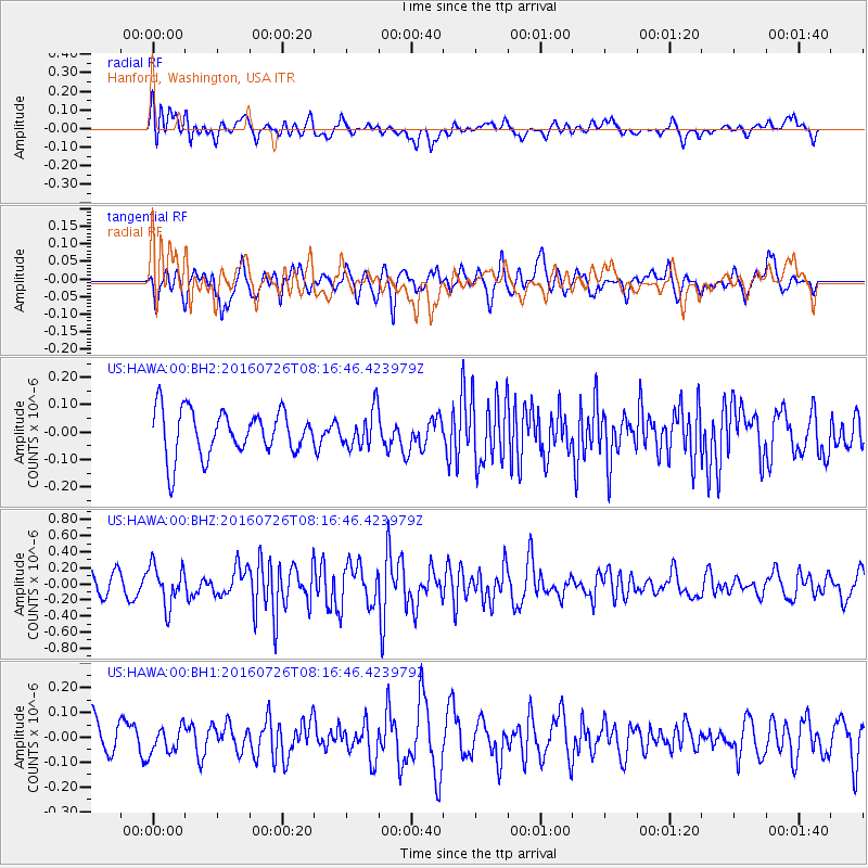
HAWA Hanford, Washington, USA - Earthquake Result Viewer
*The percent match for this event was below the threshold and hence no stack was calculated.
| Earthquake location: |
Vanuatu Islands |
| Earthquake latitude/longitude: |
-16.0/167.5 |
| Earthquake time(UTC): |
2016/07/26 (208) 08:04:20 GMT |
| Earthquake Depth: |
32 km |
| Earthquake Magnitude: |
5.8 MWW, 5.6 MWB, 5.7 MWC |
| Earthquake Catalog/Contributor: |
NEIC PDE/NEIC COMCAT |
|
| Network: |
US United States National Seismic Network |
| Station: |
HAWA Hanford, Washington, USA |
| Lat/Lon: |
46.39 N/119.53 W |
| Elevation: |
364 m |
|
| Distance: |
90.2 deg |
| Az: |
41.449 deg |
| Baz: |
246.877 deg |
| Ray Param: |
$rayparam |
*The percent match for this event was below the threshold and hence was not used in the summary stack. |
|
| Radial Match: |
58.829002 % |
| Radial Bump: |
400 |
| Transverse Match: |
46.874195 % |
| Transverse Bump: |
379 |
| SOD ConfigId: |
1634031 |
| Insert Time: |
2016-08-09 08:08:29.261 +0000 |
| GWidth: |
2.5 |
| Max Bumps: |
400 |
| Tol: |
0.001 |
|
Signal To Noise
| Channel | StoN | STA | LTA |
| US:HAWA:00:BHZ:20160726T08:16:46.423979Z | 2.2383184 | 2.523305E-7 | 1.1273218E-7 |
| US:HAWA:00:BH1:20160726T08:16:46.423979Z | 0.6067073 | 5.293051E-8 | 8.7242256E-8 |
| US:HAWA:00:BH2:20160726T08:16:46.423979Z | 0.8192805 | 6.7476705E-8 | 8.2360934E-8 |
| Arrivals |
| Ps | |
| PpPs | |
| PsPs/PpSs | |


