You are here: Home > Network List > TA - USArray Transportable Network (new EarthScope stations) Stations List
> Station U18A Rough Rock, Chinle, AZ, USA > Earthquake Result Viewer
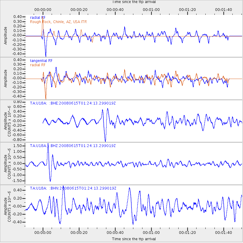
U18A Rough Rock, Chinle, AZ, USA - Earthquake Result Viewer
*The percent match for this event was below the threshold and hence no stack was calculated.
| Earthquake location: |
Fiji Islands Region |
| Earthquake latitude/longitude: |
-17.7/-179.7 |
| Earthquake time(UTC): |
2008/06/15 (167) 01:13:11 GMT |
| Earthquake Depth: |
611 km |
| Earthquake Magnitude: |
5.5 MB, 5.9 MW, 5.9 MW |
| Earthquake Catalog/Contributor: |
WHDF/NEIC |
|
| Network: |
TA USArray Transportable Network (new EarthScope stations) |
| Station: |
U18A Rough Rock, Chinle, AZ, USA |
| Lat/Lon: |
36.42 N/109.87 W |
| Elevation: |
1878 m |
|
| Distance: |
85.1 deg |
| Az: |
49.471 deg |
| Baz: |
243.911 deg |
| Ray Param: |
$rayparam |
*The percent match for this event was below the threshold and hence was not used in the summary stack. |
|
| Radial Match: |
71.47909 % |
| Radial Bump: |
400 |
| Transverse Match: |
68.275444 % |
| Transverse Bump: |
400 |
| SOD ConfigId: |
2504 |
| Insert Time: |
2010-03-06 16:26:02.082 +0000 |
| GWidth: |
2.5 |
| Max Bumps: |
400 |
| Tol: |
0.001 |
|
Signal To Noise
| Channel | StoN | STA | LTA |
| TA:U18A: :BHZ:20080615T01:24:13.299019Z | 5.5244465 | 7.5209715E-7 | 1.3613982E-7 |
| TA:U18A: :BHN:20080615T01:24:13.299019Z | 1.2941947 | 1.3290905E-7 | 1.0269633E-7 |
| TA:U18A: :BHE:20080615T01:24:13.299019Z | 3.3402736 | 3.382324E-7 | 1.012589E-7 |
| Arrivals |
| Ps | |
| PpPs | |
| PsPs/PpSs | |


