You are here: Home > Network List > TA - USArray Transportable Network (new EarthScope stations) Stations List
> Station U18A Rough Rock, Chinle, AZ, USA > Earthquake Result Viewer
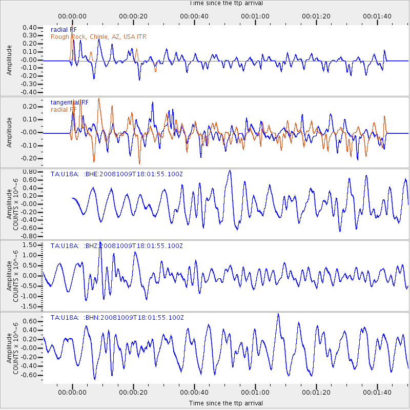
U18A Rough Rock, Chinle, AZ, USA - Earthquake Result Viewer
*The percent match for this event was below the threshold and hence no stack was calculated.
| Earthquake location: |
Tonga Islands |
| Earthquake latitude/longitude: |
-21.0/-174.4 |
| Earthquake time(UTC): |
2008/10/09 (283) 17:49:58 GMT |
| Earthquake Depth: |
10 km |
| Earthquake Magnitude: |
5.8 MB, 5.6 MS, 5.9 MW, 5.9 MW |
| Earthquake Catalog/Contributor: |
WHDF/NEIC |
|
| Network: |
TA USArray Transportable Network (new EarthScope stations) |
| Station: |
U18A Rough Rock, Chinle, AZ, USA |
| Lat/Lon: |
36.42 N/109.87 W |
| Elevation: |
1878 m |
|
| Distance: |
83.5 deg |
| Az: |
47.139 deg |
| Baz: |
238.1 deg |
| Ray Param: |
$rayparam |
*The percent match for this event was below the threshold and hence was not used in the summary stack. |
|
| Radial Match: |
69.232025 % |
| Radial Bump: |
385 |
| Transverse Match: |
71.03723 % |
| Transverse Bump: |
395 |
| SOD ConfigId: |
2556 |
| Insert Time: |
2010-03-06 16:26:09.098 +0000 |
| GWidth: |
2.5 |
| Max Bumps: |
400 |
| Tol: |
0.001 |
|
Signal To Noise
| Channel | StoN | STA | LTA |
| TA:U18A: :BHZ:20081009T18:01:55.100Z | 2.163236 | 6.210159E-7 | 2.8707726E-7 |
| TA:U18A: :BHN:20081009T18:01:55.100Z | 2.6834776 | 2.875385E-7 | 1.0715145E-7 |
| TA:U18A: :BHE:20081009T18:01:55.100Z | 1.3172208 | 2.799222E-7 | 2.1250972E-7 |
| Arrivals |
| Ps | |
| PpPs | |
| PsPs/PpSs | |


