You are here: Home > Network List > TS - TERRAscope (Southern California Seismic Network) Stations List
> Station BAR Barrett Dam, California, USA > Earthquake Result Viewer
BAR Barrett Dam, California, USA - Earthquake Result Viewer
| Earthquake location: |
Santiago Del Estero Prov., Arg. |
| Earthquake latitude/longitude: |
-28.5/-63.1 |
| Earthquake time(UTC): |
1994/05/10 (130) 06:36:28 GMT |
| Earthquake Depth: |
605 km |
| Earthquake Magnitude: |
6.4 MB, 6.2 UNKNOWN, 6.9 MW |
| Earthquake Catalog/Contributor: |
WHDF/NEIC |
|
| Network: |
TS TERRAscope (Southern California Seismic Network) |
| Station: |
BAR Barrett Dam, California, USA |
| Lat/Lon: |
32.68 N/116.67 W |
| Elevation: |
548 m |
|
| Distance: |
79.3 deg |
| Az: |
316.301 deg |
| Baz: |
133.86 deg |
| Ray Param: |
0.04714791 |
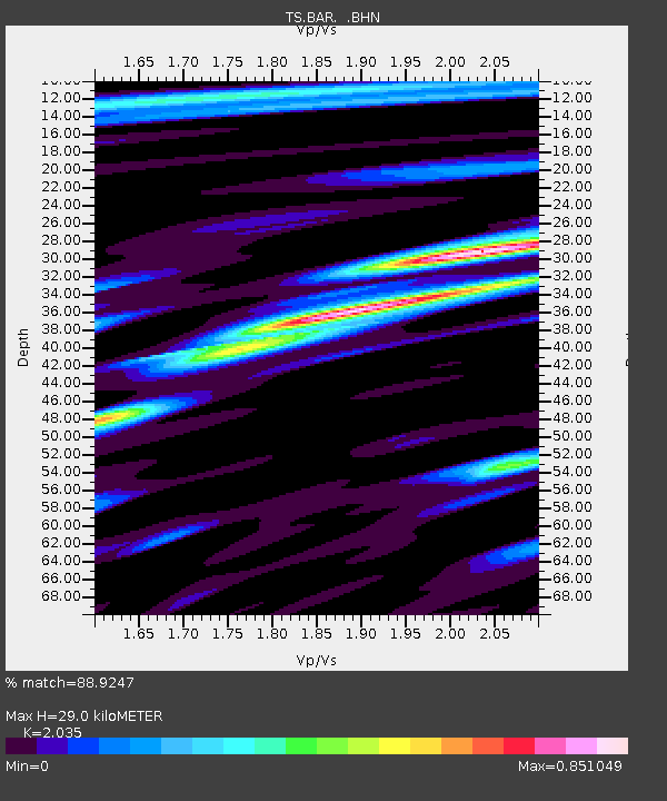
| Estimated Moho Depth: |
29.0 km |
| Estimated Crust Vp/Vs: |
2.04 |
| Assumed Crust Vp: |
6.264 km/s |
| Estimated Crust Vs: |
3.078 km/s |
| Estimated Crust Poisson's Ratio: |
0.34 |
|
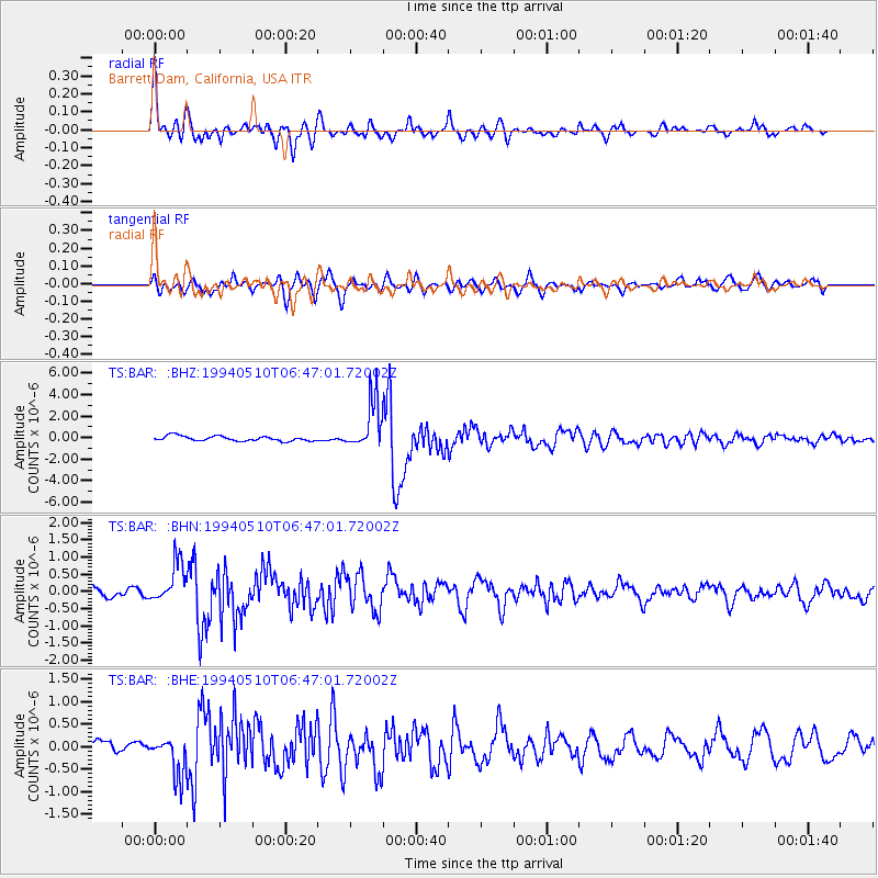
| Radial Match: |
88.9247 % |
| Radial Bump: |
400 |
| Transverse Match: |
75.606995 % |
| Transverse Bump: |
400 |
| SOD ConfigId: |
16938 |
| Insert Time: |
2010-02-26 13:57:33.965 +0000 |
| GWidth: |
2.5 |
| Max Bumps: |
400 |
| Tol: |
0.001 |
|
Signal To Noise
| Channel | StoN | STA | LTA |
| TS:BAR: :BHN:19940510T06:47:01.72002Z | 3.2731495 | 5.8241176E-7 | 1.779362E-7 |
| TS:BAR: :BHE:19940510T06:47:01.72002Z | 2.1452107 | 4.335534E-7 | 2.0210292E-7 |
| TS:BAR: :BHZ:19940510T06:47:01.72002Z | 9.963734 | 2.2325248E-6 | 2.2406508E-7 |
| Arrivals |
| Ps | 4.9 SECOND |
| PpPs | 14 SECOND |
| PsPs/PpSs | 19 SECOND |


