You are here: Home > Network List > TA - USArray Transportable Network (new EarthScope stations) Stations List
> Station R17A Hanksville Airport, Hanksville, UT, USA > Earthquake Result Viewer
R17A Hanksville Airport, Hanksville, UT, USA - Earthquake Result Viewer
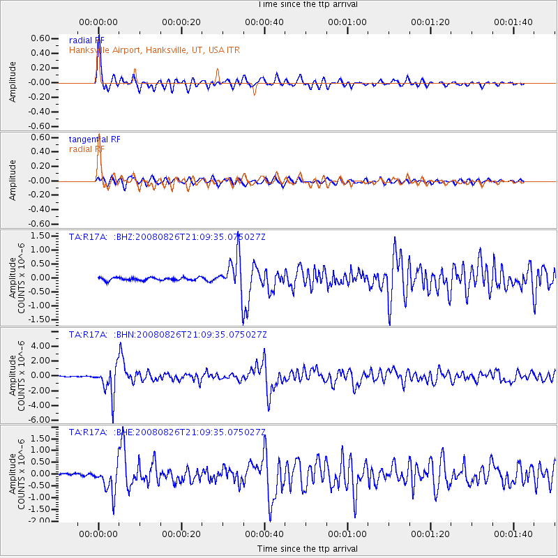
| Earthquake location: |
Peru-Brazil Border Region |
| Earthquake latitude/longitude: |
-7.6/-74.4 |
| Earthquake time(UTC): |
2008/08/26 (239) 21:00:36 GMT |
| Earthquake Depth: |
154 km |
| Earthquake Magnitude: |
6.0 MB, 6.4 MW, 6.4 MW |
| Earthquake Catalog/Contributor: |
WHDF/NEIC |
|
| Network: |
TA USArray Transportable Network (new EarthScope stations) |
| Station: |
R17A Hanksville Airport, Hanksville, UT, USA |
| Lat/Lon: |
38.42 N/110.71 W |
| Elevation: |
1357 m |
|
| Distance: |
56.9 deg |
| Az: |
326.268 deg |
| Baz: |
135.513 deg |
| Ray Param: |
0.06332636 |
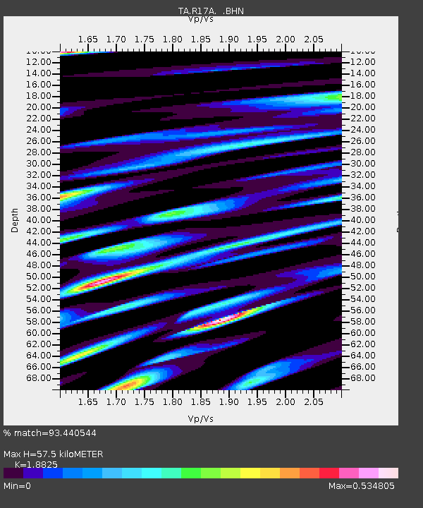
| Estimated Moho Depth: |
57.5 km |
| Estimated Crust Vp/Vs: |
1.88 |
| Assumed Crust Vp: |
6.207 km/s |
| Estimated Crust Vs: |
3.297 km/s |
| Estimated Crust Poisson's Ratio: |
0.30 |
|
| Radial Match: |
93.440544 % |
| Radial Bump: |
400 |
| Transverse Match: |
79.876396 % |
| Transverse Bump: |
400 |
| SOD ConfigId: |
2504 |
| Insert Time: |
2010-03-06 16:26:33.573 +0000 |
| GWidth: |
2.5 |
| Max Bumps: |
400 |
| Tol: |
0.001 |
|
Signal To Noise
| Channel | StoN | STA | LTA |
| TA:R17A: :BHN:20080826T21:09:35.075027Z | 30.731932 | 2.0309717E-6 | 6.608669E-8 |
| TA:R17A: :BHE:20080826T21:09:35.075027Z | 10.020553 | 6.142407E-7 | 6.129809E-8 |
| TA:R17A: :BHZ:20080826T21:09:35.075027Z | 13.413553 | 6.872861E-7 | 5.1238185E-8 |
| Arrivals |
| Ps | 8.5 SECOND |
| PpPs | 26 SECOND |
| PsPs/PpSs | 34 SECOND |


