You are here: Home > Network List > TA - USArray Transportable Network (new EarthScope stations) Stations List
> Station D23K Nanushuk River, AK USA > Earthquake Result Viewer
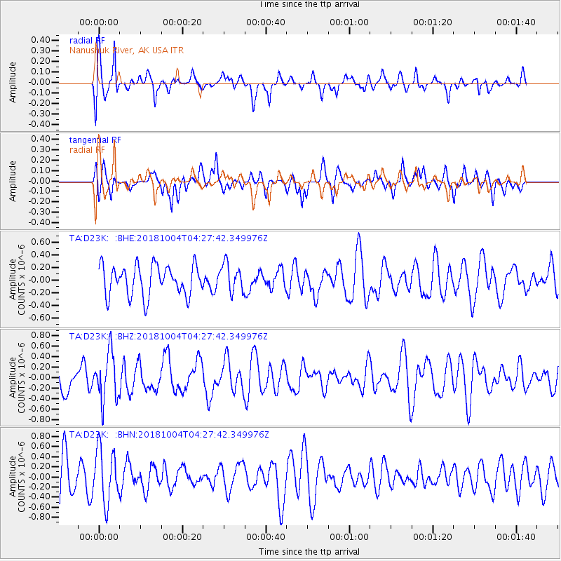
D23K Nanushuk River, AK USA - Earthquake Result Viewer
*The percent match for this event was below the threshold and hence no stack was calculated.
| Earthquake location: |
Fiji Islands Region |
| Earthquake latitude/longitude: |
-17.9/-178.5 |
| Earthquake time(UTC): |
2018/10/04 (277) 04:16:21 GMT |
| Earthquake Depth: |
579 km |
| Earthquake Magnitude: |
5.5 Mww |
| Earthquake Catalog/Contributor: |
NEIC PDE/us |
|
| Network: |
TA USArray Transportable Network (new EarthScope stations) |
| Station: |
D23K Nanushuk River, AK USA |
| Lat/Lon: |
68.97 N/150.68 W |
| Elevation: |
406 m |
|
| Distance: |
88.9 deg |
| Az: |
9.714 deg |
| Baz: |
206.43 deg |
| Ray Param: |
$rayparam |
*The percent match for this event was below the threshold and hence was not used in the summary stack. |
|
| Radial Match: |
51.3945 % |
| Radial Bump: |
400 |
| Transverse Match: |
59.37224 % |
| Transverse Bump: |
400 |
| SOD ConfigId: |
13570011 |
| Insert Time: |
2019-05-01 09:48:32.109 +0000 |
| GWidth: |
2.5 |
| Max Bumps: |
400 |
| Tol: |
0.001 |
|
Signal To Noise
| Channel | StoN | STA | LTA |
| TA:D23K: :BHZ:20181004T04:27:42.349976Z | 2.0665789 | 4.633532E-7 | 2.242127E-7 |
| TA:D23K: :BHN:20181004T04:27:42.349976Z | 1.80024 | 5.380083E-7 | 2.9885365E-7 |
| TA:D23K: :BHE:20181004T04:27:42.349976Z | 0.9795612 | 2.3403263E-7 | 2.389158E-7 |
| Arrivals |
| Ps | |
| PpPs | |
| PsPs/PpSs | |


