You are here: Home > Network List > TA - USArray Transportable Network (new EarthScope stations) Stations List
> Station R17A Hanksville Airport, Hanksville, UT, USA > Earthquake Result Viewer
R17A Hanksville Airport, Hanksville, UT, USA - Earthquake Result Viewer
| Earthquake location: |
Chile-Bolivia Border Region |
| Earthquake latitude/longitude: |
-20.0/-69.0 |
| Earthquake time(UTC): |
2008/03/24 (084) 20:39:07 GMT |
| Earthquake Depth: |
120 km |
| Earthquake Magnitude: |
5.7 MB, 6.2 MW, 6.1 MW |
| Earthquake Catalog/Contributor: |
WHDF/NEIC |
|
| Network: |
TA USArray Transportable Network (new EarthScope stations) |
| Station: |
R17A Hanksville Airport, Hanksville, UT, USA |
| Lat/Lon: |
38.42 N/110.71 W |
| Elevation: |
1357 m |
|
| Distance: |
70.1 deg |
| Az: |
326.206 deg |
| Baz: |
138.263 deg |
| Ray Param: |
0.05488721 |
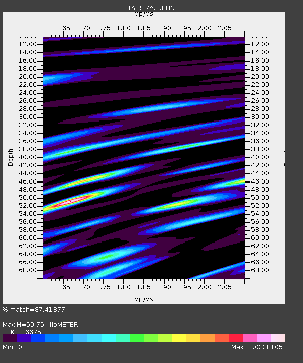
| Estimated Moho Depth: |
50.75 km |
| Estimated Crust Vp/Vs: |
1.67 |
| Assumed Crust Vp: |
6.207 km/s |
| Estimated Crust Vs: |
3.722 km/s |
| Estimated Crust Poisson's Ratio: |
0.22 |
|
| Radial Match: |
87.41877 % |
| Radial Bump: |
400 |
| Transverse Match: |
80.31651 % |
| Transverse Bump: |
400 |
| SOD ConfigId: |
2564 |
| Insert Time: |
2010-03-06 16:26:52.505 +0000 |
| GWidth: |
2.5 |
| Max Bumps: |
400 |
| Tol: |
0.001 |
|
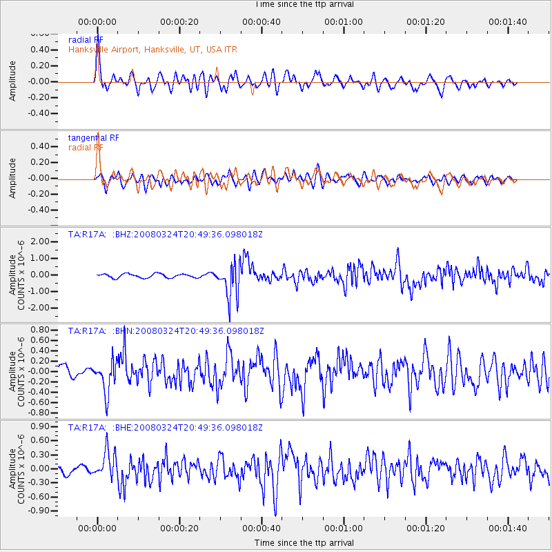
Signal To Noise
| Channel | StoN | STA | LTA |
| TA:R17A: :BHN:20080324T20:49:36.098018Z | 2.2737482 | 3.1289207E-7 | 1.376107E-7 |
| TA:R17A: :BHE:20080324T20:49:36.098018Z | 3.7138486 | 2.9878422E-7 | 8.045137E-8 |
| TA:R17A: :BHZ:20080324T20:49:36.098018Z | 8.7058525 | 1.0506553E-6 | 1.206838E-7 |
| Arrivals |
| Ps | 5.7 SECOND |
| PpPs | 21 SECOND |
| PsPs/PpSs | 27 SECOND |


