You are here: Home > Network List > TA - USArray Transportable Network (new EarthScope stations) Stations List
> Station R17A Hanksville Airport, Hanksville, UT, USA > Earthquake Result Viewer
R17A Hanksville Airport, Hanksville, UT, USA - Earthquake Result Viewer
| Earthquake location: |
Svalbard Region |
| Earthquake latitude/longitude: |
77.1/18.6 |
| Earthquake time(UTC): |
2008/02/21 (052) 02:46:17 GMT |
| Earthquake Depth: |
10 km |
| Earthquake Magnitude: |
5.7 MB, 5.9 MS, 6.1 MW, 6.0 MW |
| Earthquake Catalog/Contributor: |
WHDF/NEIC |
|
| Network: |
TA USArray Transportable Network (new EarthScope stations) |
| Station: |
R17A Hanksville Airport, Hanksville, UT, USA |
| Lat/Lon: |
38.42 N/110.71 W |
| Elevation: |
1357 m |
|
| Distance: |
60.6 deg |
| Az: |
315.737 deg |
| Baz: |
11.533 deg |
| Ray Param: |
0.061431814 |
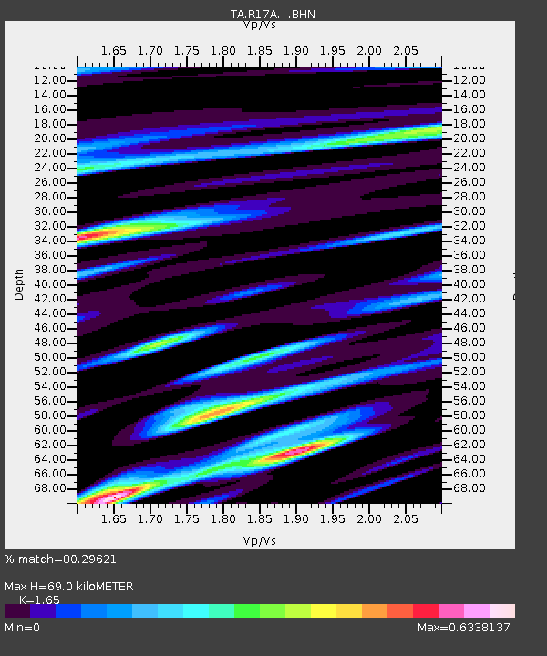
| Estimated Moho Depth: |
69.0 km |
| Estimated Crust Vp/Vs: |
1.65 |
| Assumed Crust Vp: |
6.207 km/s |
| Estimated Crust Vs: |
3.762 km/s |
| Estimated Crust Poisson's Ratio: |
0.21 |
|
| Radial Match: |
80.29621 % |
| Radial Bump: |
400 |
| Transverse Match: |
70.154205 % |
| Transverse Bump: |
400 |
| SOD ConfigId: |
2564 |
| Insert Time: |
2010-03-06 16:27:03.527 +0000 |
| GWidth: |
2.5 |
| Max Bumps: |
400 |
| Tol: |
0.001 |
|
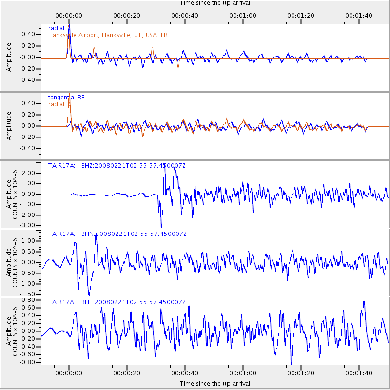
Signal To Noise
| Channel | StoN | STA | LTA |
| TA:R17A: :BHN:20080221T02:55:57.450007Z | 3.4228673 | 5.5947254E-7 | 1.6345143E-7 |
| TA:R17A: :BHE:20080221T02:55:57.450007Z | 3.4435194 | 2.495944E-7 | 7.248236E-8 |
| TA:R17A: :BHZ:20080221T02:55:57.450007Z | 13.79168 | 1.2814006E-6 | 9.291113E-8 |
| Arrivals |
| Ps | 7.6 SECOND |
| PpPs | 28 SECOND |
| PsPs/PpSs | 36 SECOND |


