You are here: Home > Network List > TA - USArray Transportable Network (new EarthScope stations) Stations List
> Station R17A Hanksville Airport, Hanksville, UT, USA > Earthquake Result Viewer
R17A Hanksville Airport, Hanksville, UT, USA - Earthquake Result Viewer
| Earthquake location: |
Costa Rica |
| Earthquake latitude/longitude: |
10.2/-84.2 |
| Earthquake time(UTC): |
2009/01/08 (008) 19:21:35 GMT |
| Earthquake Depth: |
14 km |
| Earthquake Magnitude: |
5.7 MB, 6.0 MS, 6.1 MW, 6.1 MW |
| Earthquake Catalog/Contributor: |
WHDF/NEIC |
|
| Network: |
TA USArray Transportable Network (new EarthScope stations) |
| Station: |
R17A Hanksville Airport, Hanksville, UT, USA |
| Lat/Lon: |
38.42 N/110.71 W |
| Elevation: |
1357 m |
|
| Distance: |
36.8 deg |
| Az: |
324.189 deg |
| Baz: |
132.833 deg |
| Ray Param: |
0.076462604 |
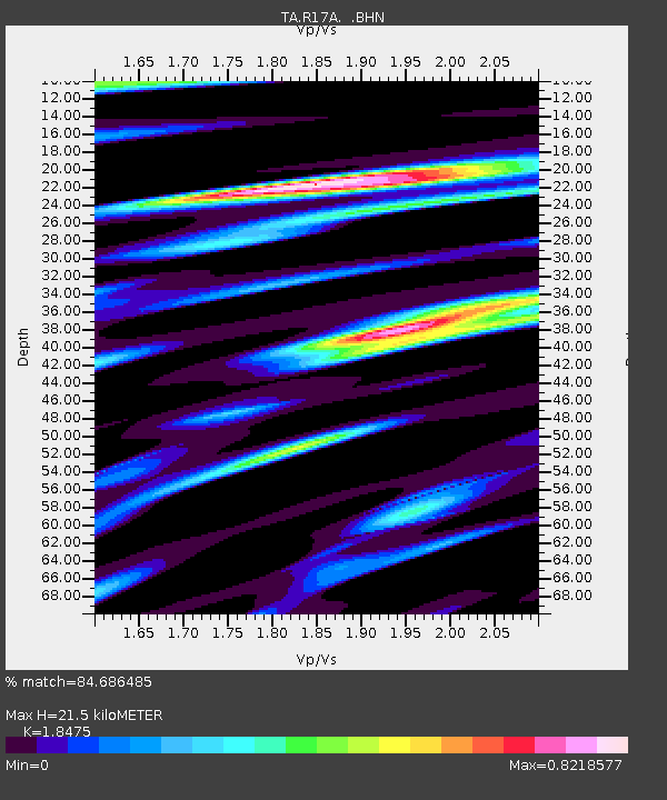
| Estimated Moho Depth: |
21.5 km |
| Estimated Crust Vp/Vs: |
1.85 |
| Assumed Crust Vp: |
6.207 km/s |
| Estimated Crust Vs: |
3.36 km/s |
| Estimated Crust Poisson's Ratio: |
0.29 |
|
| Radial Match: |
84.686485 % |
| Radial Bump: |
400 |
| Transverse Match: |
52.64629 % |
| Transverse Bump: |
400 |
| SOD ConfigId: |
2834 |
| Insert Time: |
2010-03-06 16:27:05.023 +0000 |
| GWidth: |
2.5 |
| Max Bumps: |
400 |
| Tol: |
0.001 |
|
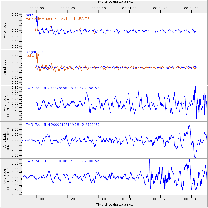
Signal To Noise
| Channel | StoN | STA | LTA |
| TA:R17A: :BHN:20090108T19:28:12.250015Z | 3.555206 | 4.6787136E-7 | 1.3160177E-7 |
| TA:R17A: :BHE:20090108T19:28:12.250015Z | 1.0225495 | 1.4548858E-7 | 1.4228024E-7 |
| TA:R17A: :BHZ:20090108T19:28:12.250015Z | 2.3794281 | 3.1204866E-7 | 1.3114439E-7 |
| Arrivals |
| Ps | 3.1 SECOND |
| PpPs | 9.2 SECOND |
| PsPs/PpSs | 12 SECOND |


