PMSA Palmer Station, Antarctica - Earthquake Result Viewer
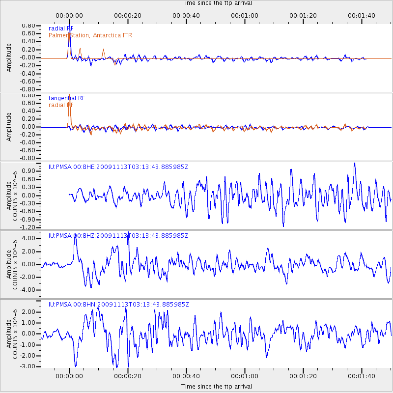
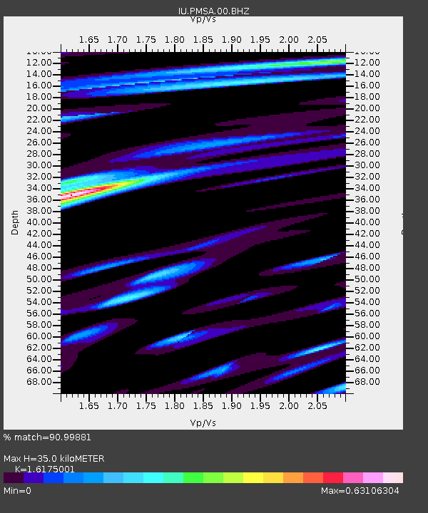
Earthquake location: Near Coast Of Northern Chile
Earthquake latitude/longitude: -19.4/-70.3
Earthquake time(UTC): 2009/11/13 (317) 03:05:57 GMT
Earthquake Depth: 27 km
Earthquake Magnitude: 6.2 MB, 6.4 MS, 6.5 MW, 6.5 MW
Earthquake Catalog/Contributor: WHDF/NEIC
Network: IU Global Seismograph Network (GSN - IRIS/USGS)
Station: PMSA Palmer Station, Antarctica
Lat/Lon: 64.77 S/64.05 W
Elevation: 40 m
Distance: 45.5 deg
Az: 176.239 deg
Baz: 351.693 deg
Ray Param: 0.07115754
Estimated Moho Depth: 35.0 km
Estimated Crust Vp/Vs: 1.62
Assumed Crust Vp: 6.183 km/s
Estimated Crust Vs: 3.822 km/s
Estimated Crust Poisson's Ratio: 0.19
Radial Match: 90.99881 %
Radial Bump: 322
Transverse Match: 72.865524 %
Transverse Bump: 400
SOD ConfigId: 1
Insert Time: 2010-02-19 01:10:55.031 +0000
GWidth: 2.5
Max Bumps: 400
Tol: 0.001

Signal To Noise

ChannelStoNSTALTA
IU:PMSA:00:BHZ:20091113T03:13:43.885985Z9.0170241.8504784E-62.0522052E-7
IU:PMSA:00:BHN:20091113T03:13:43.885985Z6.1337561.2227008E-61.9933965E-7
IU:PMSA:00:BHE:20091113T03:13:43.885985Z1.19219482.0311795E-71.7037311E-7
Arrivals
Ps3.7 SECOND
PpPs14 SECOND
PsPs/PpSs18 SECOND