You are here: Home > Network List > TS - TERRAscope (Southern California Seismic Network) Stations List
> Station BAR Barrett Dam, California, USA > Earthquake Result Viewer
BAR Barrett Dam, California, USA - Earthquake Result Viewer
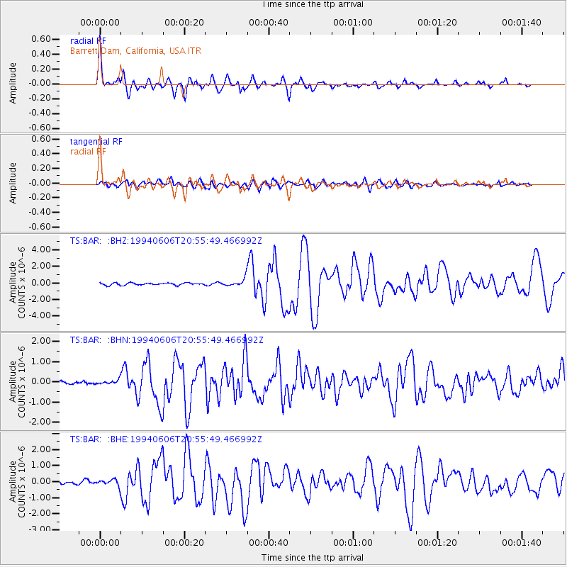
| Earthquake location: |
Colombia |
| Earthquake latitude/longitude: |
2.9/-76.1 |
| Earthquake time(UTC): |
1994/06/06 (157) 20:47:39 GMT |
| Earthquake Depth: |
9.0 km |
| Earthquake Magnitude: |
6.4 MB, 6.4 MS, 6.3 UNKNOWN, 6.8 MW |
| Earthquake Catalog/Contributor: |
WHDF/NEIC |
|
| Network: |
TS TERRAscope (Southern California Seismic Network) |
| Station: |
BAR Barrett Dam, California, USA |
| Lat/Lon: |
32.68 N/116.67 W |
| Elevation: |
548 m |
|
| Distance: |
48.2 deg |
| Az: |
312.602 deg |
| Baz: |
119.343 deg |
| Ray Param: |
0.069522366 |
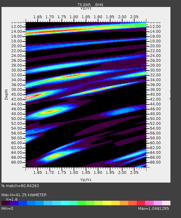
| Estimated Moho Depth: |
41.25 km |
| Estimated Crust Vp/Vs: |
1.60 |
| Assumed Crust Vp: |
6.264 km/s |
| Estimated Crust Vs: |
3.915 km/s |
| Estimated Crust Poisson's Ratio: |
0.18 |
|
| Radial Match: |
90.94263 % |
| Radial Bump: |
400 |
| Transverse Match: |
77.27787 % |
| Transverse Bump: |
400 |
| SOD ConfigId: |
16938 |
| Insert Time: |
2010-02-26 13:57:36.738 +0000 |
| GWidth: |
2.5 |
| Max Bumps: |
400 |
| Tol: |
0.001 |
|
Signal To Noise
| Channel | StoN | STA | LTA |
| TS:BAR: :BHN:19940606T20:55:49.466992Z | 1.5236573 | 1.4232076E-7 | 9.340732E-8 |
| TS:BAR: :BHE:19940606T20:55:49.466992Z | 2.6110537 | 2.0109887E-7 | 7.701828E-8 |
| TS:BAR: :BHZ:19940606T20:55:49.466992Z | 3.6834917 | 4.996042E-7 | 1.3563331E-7 |
| Arrivals |
| Ps | 4.2 SECOND |
| PpPs | 16 SECOND |
| PsPs/PpSs | 20 SECOND |


