You are here: Home > Network List > TA - USArray Transportable Network (new EarthScope stations) Stations List
> Station R17A Hanksville Airport, Hanksville, UT, USA > Earthquake Result Viewer
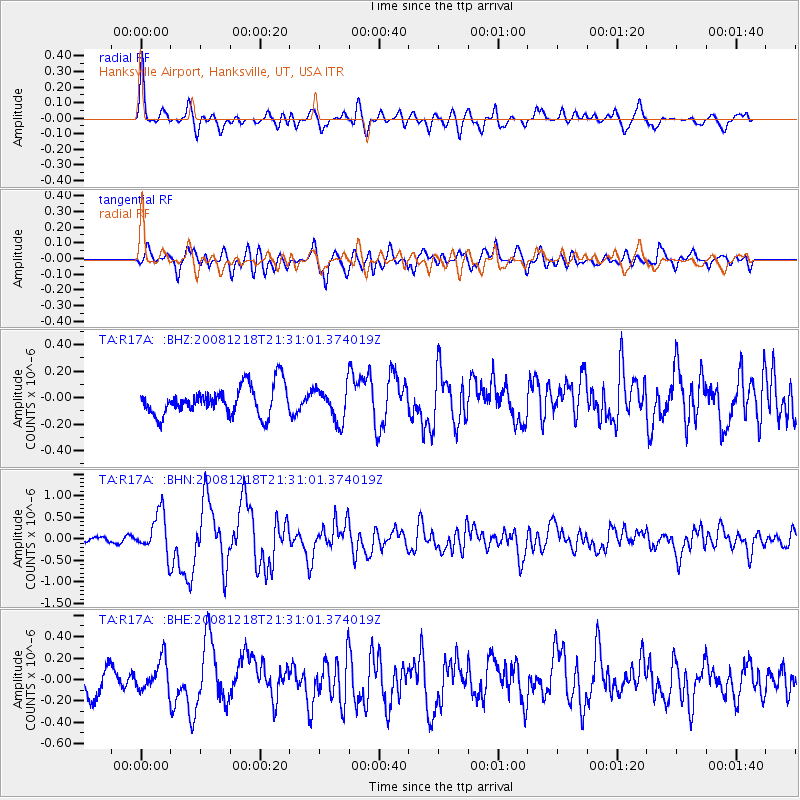
R17A Hanksville Airport, Hanksville, UT, USA - Earthquake Result Viewer
| Earthquake location: |
Near Coast Of Central Chile |
| Earthquake latitude/longitude: |
-32.5/-71.7 |
| Earthquake time(UTC): |
2008/12/18 (353) 21:19:28 GMT |
| Earthquake Depth: |
18 km |
| Earthquake Magnitude: |
5.8 MB, 6.0 MS, 6.2 MW, 6.1 MW |
| Earthquake Catalog/Contributor: |
WHDF/NEIC |
|
| Network: |
TA USArray Transportable Network (new EarthScope stations) |
| Station: |
R17A Hanksville Airport, Hanksville, UT, USA |
| Lat/Lon: |
38.42 N/110.71 W |
| Elevation: |
1357 m |
|
| Distance: |
79.3 deg |
| Az: |
329.806 deg |
| Baz: |
147.23 deg |
| Ray Param: |
0.049040806 |
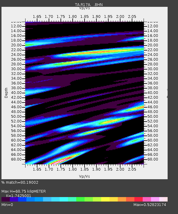
| Estimated Moho Depth: |
68.75 km |
| Estimated Crust Vp/Vs: |
1.74 |
| Assumed Crust Vp: |
6.207 km/s |
| Estimated Crust Vs: |
3.562 km/s |
| Estimated Crust Poisson's Ratio: |
0.25 |
|
| Radial Match: |
80.19002 % |
| Radial Bump: |
400 |
| Transverse Match: |
74.332504 % |
| Transverse Bump: |
400 |
| SOD ConfigId: |
2658 |
| Insert Time: |
2010-03-06 16:27:09.246 +0000 |
| GWidth: |
2.5 |
| Max Bumps: |
400 |
| Tol: |
0.001 |
|
Signal To Noise
| Channel | StoN | STA | LTA |
| TA:R17A: :BHN:20081218T21:31:01.374019Z | 6.1522098 | 4.77586E-7 | 7.762837E-8 |
| TA:R17A: :BHE:20081218T21:31:01.374019Z | 1.2869511 | 1.4506543E-7 | 1.1272024E-7 |
| TA:R17A: :BHZ:20081218T21:31:01.374019Z | 1.1748574 | 1.2944022E-7 | 1.1017526E-7 |
| Arrivals |
| Ps | 8.5 SECOND |
| PpPs | 30 SECOND |
| PsPs/PpSs | 38 SECOND |


