You are here: Home > Network List > TA - USArray Transportable Network (new EarthScope stations) Stations List
> Station R17A Hanksville Airport, Hanksville, UT, USA > Earthquake Result Viewer
R17A Hanksville Airport, Hanksville, UT, USA - Earthquake Result Viewer
| Earthquake location: |
Kuril Islands |
| Earthquake latitude/longitude: |
45.8/150.1 |
| Earthquake time(UTC): |
2007/09/03 (246) 16:14:53 GMT |
| Earthquake Depth: |
94 km |
| Earthquake Magnitude: |
6.3 MB, 6.2 MW, 6.2 ME |
| Earthquake Catalog/Contributor: |
WHDF/NEIC |
|
| Network: |
TA USArray Transportable Network (new EarthScope stations) |
| Station: |
R17A Hanksville Airport, Hanksville, UT, USA |
| Lat/Lon: |
38.42 N/110.71 W |
| Elevation: |
1357 m |
|
| Distance: |
69.2 deg |
| Az: |
56.013 deg |
| Baz: |
312.442 deg |
| Ray Param: |
0.05554123 |
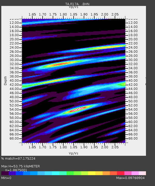
| Estimated Moho Depth: |
53.75 km |
| Estimated Crust Vp/Vs: |
1.87 |
| Assumed Crust Vp: |
6.207 km/s |
| Estimated Crust Vs: |
3.324 km/s |
| Estimated Crust Poisson's Ratio: |
0.30 |
|
| Radial Match: |
87.175224 % |
| Radial Bump: |
353 |
| Transverse Match: |
85.24681 % |
| Transverse Bump: |
362 |
| SOD ConfigId: |
2564 |
| Insert Time: |
2010-03-06 16:27:31.643 +0000 |
| GWidth: |
2.5 |
| Max Bumps: |
400 |
| Tol: |
0.001 |
|
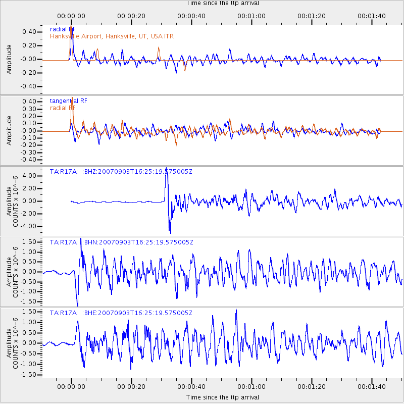
Signal To Noise
| Channel | StoN | STA | LTA |
| TA:R17A: :BHN:20070903T16:25:19.575005Z | 13.142176 | 7.5969047E-7 | 5.7805533E-8 |
| TA:R17A: :BHE:20070903T16:25:19.575005Z | 6.7817264 | 5.497802E-7 | 8.106788E-8 |
| TA:R17A: :BHZ:20070903T16:25:19.575005Z | 36.013145 | 2.478053E-6 | 6.8809676E-8 |
| Arrivals |
| Ps | 7.8 SECOND |
| PpPs | 24 SECOND |
| PsPs/PpSs | 32 SECOND |


