You are here: Home > Network List > CI - Caltech Regional Seismic Network Stations List
> Station LRL Laurel Mtn Radio Fac, Ridgecrest, CA, USA > Earthquake Result Viewer
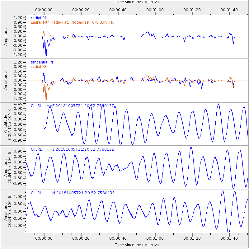
LRL Laurel Mtn Radio Fac, Ridgecrest, CA, USA - Earthquake Result Viewer
*The percent match for this event was below the threshold and hence no stack was calculated.
| Earthquake location: |
Southeast Of Loyalty Islands |
| Earthquake latitude/longitude: |
-22.0/169.6 |
| Earthquake time(UTC): |
2018/10/05 (278) 21:08:26 GMT |
| Earthquake Depth: |
5.6 km |
| Earthquake Magnitude: |
5.4 Mww |
| Earthquake Catalog/Contributor: |
NEIC PDE/us |
|
| Network: |
CI Caltech Regional Seismic Network |
| Station: |
LRL Laurel Mtn Radio Fac, Ridgecrest, CA, USA |
| Lat/Lon: |
35.48 N/117.68 W |
| Elevation: |
1340 m |
|
| Distance: |
89.4 deg |
| Az: |
51.201 deg |
| Baz: |
242.415 deg |
| Ray Param: |
$rayparam |
*The percent match for this event was below the threshold and hence was not used in the summary stack. |
|
| Radial Match: |
75.74677 % |
| Radial Bump: |
400 |
| Transverse Match: |
44.284866 % |
| Transverse Bump: |
400 |
| SOD ConfigId: |
13570011 |
| Insert Time: |
2019-05-01 09:59:29.307 +0000 |
| GWidth: |
2.5 |
| Max Bumps: |
400 |
| Tol: |
0.001 |
|
Signal To Noise
| Channel | StoN | STA | LTA |
| CI:LRL: :HHZ:20181005T21:20:52.758013Z | 1.9370294 | 5.342421E-7 | 2.7580484E-7 |
| CI:LRL: :HHN:20181005T21:20:52.758013Z | 0.5298923 | 3.645505E-7 | 6.8797084E-7 |
| CI:LRL: :HHE:20181005T21:20:52.758013Z | 1.3492925 | 7.352208E-7 | 5.4489357E-7 |
| Arrivals |
| Ps | |
| PpPs | |
| PsPs/PpSs | |


