You are here: Home > Network List > TA - USArray Transportable Network (new EarthScope stations) Stations List
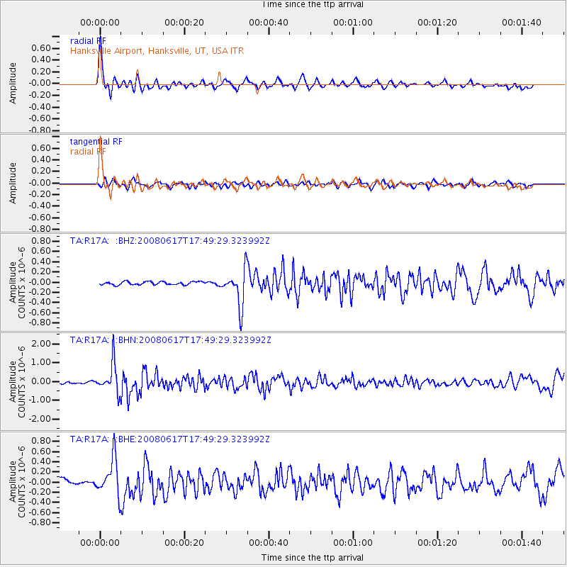
> Station R17A Hanksville Airport, Hanksville, UT, USA > Earthquake Result Viewer
R17A Hanksville Airport, Hanksville, UT, USA - Earthquake Result Viewer
| Earthquake location: |
South Of Panama |
| Earthquake latitude/longitude: |
5.0/-82.7 |
| Earthquake time(UTC): |
2008/06/17 (169) 17:42:09 GMT |
| Earthquake Depth: |
10 km |
| Earthquake Magnitude: |
5.6 MB, 5.3 MS, 5.9 MW, 5.9 MW |
| Earthquake Catalog/Contributor: |
WHDF/NEIC |
|
| Network: |
TA USArray Transportable Network (new EarthScope stations) |
| Station: |
R17A Hanksville Airport, Hanksville, UT, USA |
| Lat/Lon: |
38.42 N/110.71 W |
| Elevation: |
1357 m |
|
| Distance: |
41.9 deg |
| Az: |
326.413 deg |
| Baz: |
135.444 deg |
| Ray Param: |
0.07349466 |
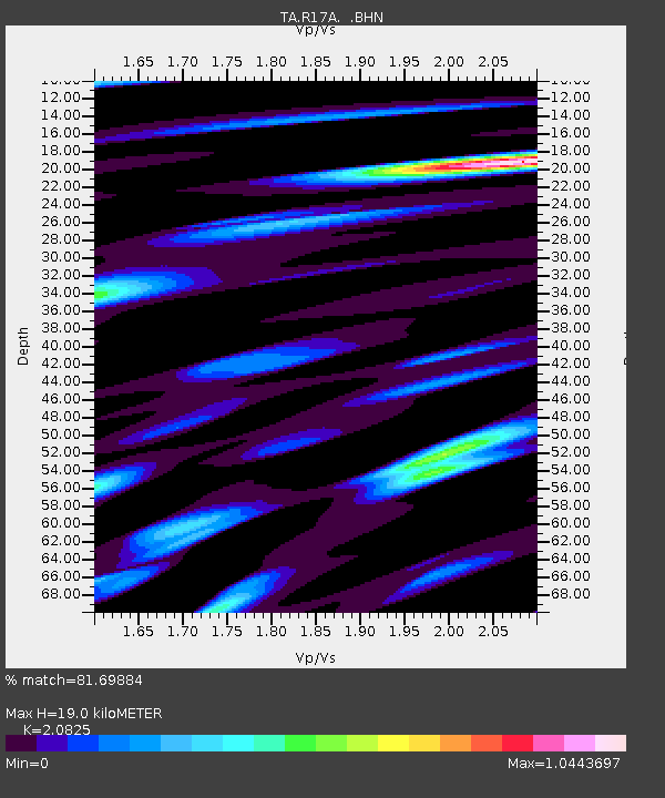
| Estimated Moho Depth: |
19.0 km |
| Estimated Crust Vp/Vs: |
2.08 |
| Assumed Crust Vp: |
6.207 km/s |
| Estimated Crust Vs: |
2.98 km/s |
| Estimated Crust Poisson's Ratio: |
0.35 |
|
| Radial Match: |
81.69884 % |
| Radial Bump: |
400 |
| Transverse Match: |
66.38351 % |
| Transverse Bump: |
400 |
| SOD ConfigId: |
2504 |
| Insert Time: |
2010-03-06 16:28:13.060 +0000 |
| GWidth: |
2.5 |
| Max Bumps: |
400 |
| Tol: |
0.001 |
|
Signal To Noise
| Channel | StoN | STA | LTA |
| TA:R17A: :BHN:20080617T17:49:29.323992Z | 11.27503 | 7.9388695E-7 | 7.0411076E-8 |
| TA:R17A: :BHE:20080617T17:49:29.323992Z | 4.4960203 | 3.7068406E-7 | 8.244715E-8 |
| TA:R17A: :BHZ:20080617T17:49:29.323992Z | 11.840102 | 3.698414E-7 | 3.1236333E-8 |
| Arrivals |
| Ps | 3.5 SECOND |
| PpPs | 8.9 SECOND |
| PsPs/PpSs | 12 SECOND |


