You are here: Home > Network List > TA - USArray Transportable Network (new EarthScope stations) Stations List
> Station R17A Hanksville Airport, Hanksville, UT, USA > Earthquake Result Viewer
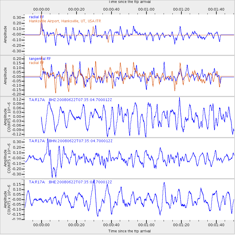
R17A Hanksville Airport, Hanksville, UT, USA - Earthquake Result Viewer
*The percent match for this event was below the threshold and hence no stack was calculated.
| Earthquake location: |
Solomon Islands |
| Earthquake latitude/longitude: |
-8.9/157.8 |
| Earthquake time(UTC): |
2008/06/22 (174) 07:22:06 GMT |
| Earthquake Depth: |
10 km |
| Earthquake Magnitude: |
5.5 MB, 5.5 MS, 5.8 MW, 5.7 MW |
| Earthquake Catalog/Contributor: |
WHDF/NEIC |
|
| Network: |
TA USArray Transportable Network (new EarthScope stations) |
| Station: |
R17A Hanksville Airport, Hanksville, UT, USA |
| Lat/Lon: |
38.42 N/110.71 W |
| Elevation: |
1357 m |
|
| Distance: |
96.6 deg |
| Az: |
52.231 deg |
| Baz: |
263.967 deg |
| Ray Param: |
$rayparam |
*The percent match for this event was below the threshold and hence was not used in the summary stack. |
|
| Radial Match: |
61.38814 % |
| Radial Bump: |
400 |
| Transverse Match: |
54.75668 % |
| Transverse Bump: |
362 |
| SOD ConfigId: |
2504 |
| Insert Time: |
2010-03-06 16:28:39.512 +0000 |
| GWidth: |
2.5 |
| Max Bumps: |
400 |
| Tol: |
0.001 |
|
Signal To Noise
| Channel | StoN | STA | LTA |
| TA:R17A: :BHN:20080622T07:35:04.700012Z | 3.278456 | 1.4318991E-7 | 4.367602E-8 |
| TA:R17A: :BHE:20080622T07:35:04.700012Z | 0.3172587 | 1.2293562E-8 | 3.874933E-8 |
| TA:R17A: :BHZ:20080622T07:35:04.700012Z | 0.48004064 | 2.539715E-8 | 5.290625E-8 |
| Arrivals |
| Ps | |
| PpPs | |
| PsPs/PpSs | |


