You are here: Home > Network List > TA - USArray Transportable Network (new EarthScope stations) Stations List
> Station B18K Kokolik River, AK, USA > Earthquake Result Viewer
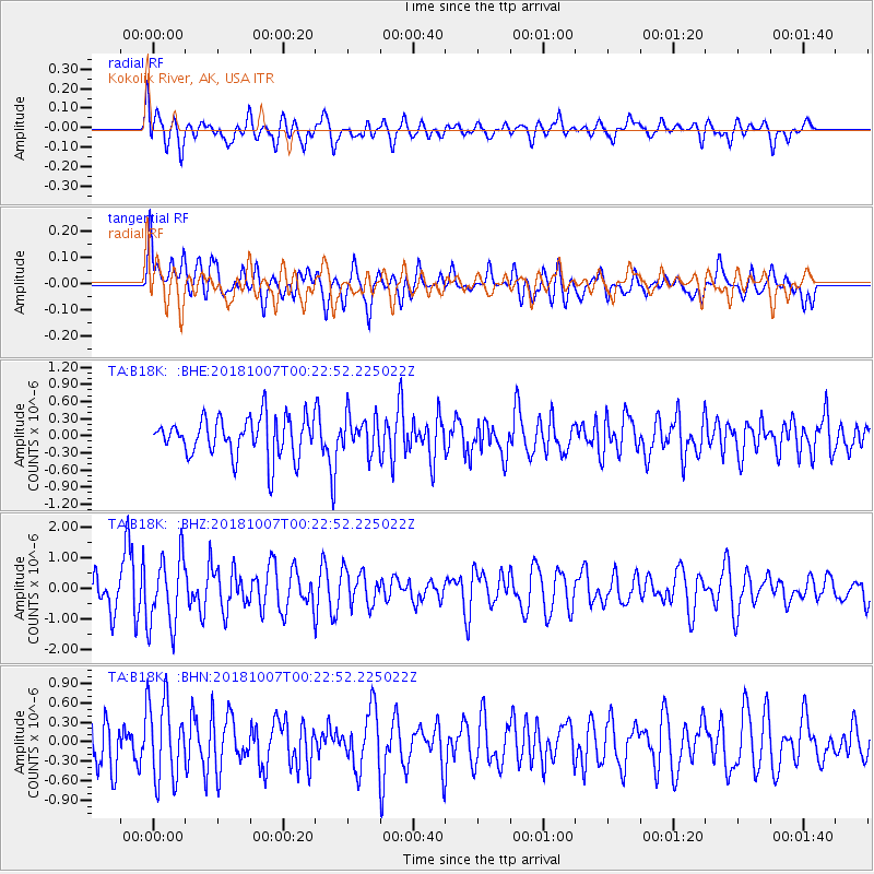
B18K Kokolik River, AK, USA - Earthquake Result Viewer
*The percent match for this event was below the threshold and hence no stack was calculated.
| Earthquake location: |
Central Mid-Atlantic Ridge |
| Earthquake latitude/longitude: |
7.6/-37.7 |
| Earthquake time(UTC): |
2018/10/07 (280) 00:10:05 GMT |
| Earthquake Depth: |
10 km |
| Earthquake Magnitude: |
5.6 Mww |
| Earthquake Catalog/Contributor: |
NEIC PDE/us |
|
| Network: |
TA USArray Transportable Network (new EarthScope stations) |
| Station: |
B18K Kokolik River, AK, USA |
| Lat/Lon: |
69.36 N/161.80 W |
| Elevation: |
222 m |
|
| Distance: |
94.3 deg |
| Az: |
342.888 deg |
| Baz: |
55.367 deg |
| Ray Param: |
$rayparam |
*The percent match for this event was below the threshold and hence was not used in the summary stack. |
|
| Radial Match: |
53.867535 % |
| Radial Bump: |
400 |
| Transverse Match: |
60.708843 % |
| Transverse Bump: |
400 |
| SOD ConfigId: |
13570011 |
| Insert Time: |
2019-05-01 10:10:41.972 +0000 |
| GWidth: |
2.5 |
| Max Bumps: |
400 |
| Tol: |
0.001 |
|
Signal To Noise
| Channel | StoN | STA | LTA |
| TA:B18K: :BHZ:20181007T00:22:52.225022Z | 1.639387 | 1.1351497E-6 | 6.924232E-7 |
| TA:B18K: :BHN:20181007T00:22:52.225022Z | 1.6604445 | 6.1290143E-7 | 3.6911888E-7 |
| TA:B18K: :BHE:20181007T00:22:52.225022Z | 0.9034044 | 3.2740775E-7 | 3.6241548E-7 |
| Arrivals |
| Ps | |
| PpPs | |
| PsPs/PpSs | |


