You are here: Home > Network List > G - GEOSCOPE Stations List
> Station MPG Montagne des Peres, French Guyana > Earthquake Result Viewer
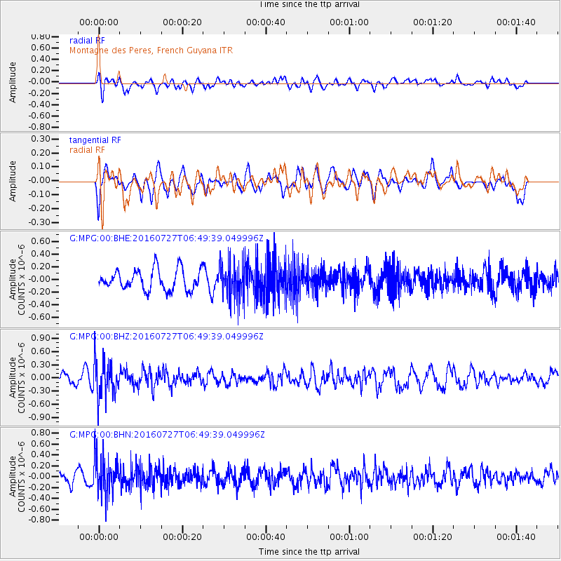
MPG Montagne des Peres, French Guyana - Earthquake Result Viewer
*The percent match for this event was below the threshold and hence no stack was calculated.
| Earthquake location: |
Chile-Argentina Border Region |
| Earthquake latitude/longitude: |
-24.3/-67.9 |
| Earthquake time(UTC): |
2016/07/27 (209) 06:43:45 GMT |
| Earthquake Depth: |
99 km |
| Earthquake Magnitude: |
5.6 MB |
| Earthquake Catalog/Contributor: |
NEIC PDE/NEIC COMCAT |
|
| Network: |
G GEOSCOPE |
| Station: |
MPG Montagne des Peres, French Guyana |
| Lat/Lon: |
5.11 N/52.64 W |
| Elevation: |
147 m |
|
| Distance: |
32.8 deg |
| Az: |
28.894 deg |
| Baz: |
206.274 deg |
| Ray Param: |
$rayparam |
*The percent match for this event was below the threshold and hence was not used in the summary stack. |
|
| Radial Match: |
49.511417 % |
| Radial Bump: |
400 |
| Transverse Match: |
55.90838 % |
| Transverse Bump: |
400 |
| SOD ConfigId: |
1634031 |
| Insert Time: |
2016-08-10 06:44:51.106 +0000 |
| GWidth: |
2.5 |
| Max Bumps: |
400 |
| Tol: |
0.001 |
|
Signal To Noise
| Channel | StoN | STA | LTA |
| G:MPG:00:BHZ:20160727T06:49:39.049996Z | 3.4721284 | 4.1994366E-7 | 1.2094704E-7 |
| G:MPG:00:BHN:20160727T06:49:39.049996Z | 4.05788 | 3.4967047E-7 | 8.617073E-8 |
| G:MPG:00:BHE:20160727T06:49:39.049996Z | 1.7630816 | 2.8645132E-7 | 1.6247196E-7 |
| Arrivals |
| Ps | |
| PpPs | |
| PsPs/PpSs | |


