You are here: Home > Network List > TS - TERRAscope (Southern California Seismic Network) Stations List
> Station BAR Barrett Dam, California, USA > Earthquake Result Viewer
BAR Barrett Dam, California, USA - Earthquake Result Viewer
| Earthquake location: |
Primor'ye, Russia |
| Earthquake latitude/longitude: |
42.3/132.9 |
| Earthquake time(UTC): |
1994/07/21 (202) 18:36:31 GMT |
| Earthquake Depth: |
473 km |
| Earthquake Magnitude: |
6.4 MB, 7.2 UNKNOWN |
| Earthquake Catalog/Contributor: |
WHDF/NEIC |
|
| Network: |
TS TERRAscope (Southern California Seismic Network) |
| Station: |
BAR Barrett Dam, California, USA |
| Lat/Lon: |
32.68 N/116.67 W |
| Elevation: |
548 m |
|
| Distance: |
81.8 deg |
| Az: |
52.972 deg |
| Baz: |
315.39 deg |
| Ray Param: |
0.045955513 |
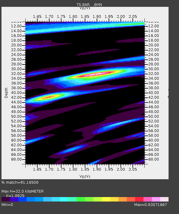
| Estimated Moho Depth: |
32.0 km |
| Estimated Crust Vp/Vs: |
1.89 |
| Assumed Crust Vp: |
6.264 km/s |
| Estimated Crust Vs: |
3.31 km/s |
| Estimated Crust Poisson's Ratio: |
0.31 |
|
| Radial Match: |
91.16508 % |
| Radial Bump: |
338 |
| Transverse Match: |
87.300575 % |
| Transverse Bump: |
400 |
| SOD ConfigId: |
16938 |
| Insert Time: |
2010-02-26 13:57:39.786 +0000 |
| GWidth: |
2.5 |
| Max Bumps: |
400 |
| Tol: |
0.001 |
|
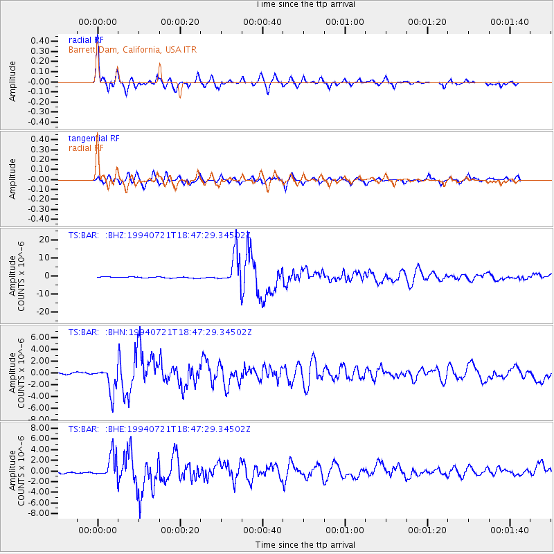
Signal To Noise
| Channel | StoN | STA | LTA |
| TS:BAR: :BHN:19940721T18:47:29.34502Z | 17.048523 | 2.3206774E-6 | 1.361219E-7 |
| TS:BAR: :BHE:19940721T18:47:29.34502Z | 13.575745 | 2.2728304E-6 | 1.6741848E-7 |
| TS:BAR: :BHZ:19940721T18:47:29.34502Z | 32.475765 | 9.116762E-6 | 2.8072512E-7 |
| Arrivals |
| Ps | 4.7 SECOND |
| PpPs | 14 SECOND |
| PsPs/PpSs | 19 SECOND |


