You are here: Home > Network List > AV - Alaska Volcano Observatory Stations List
> Station SPCR Ckakachatna River, Mount Spurr, Alaska > Earthquake Result Viewer
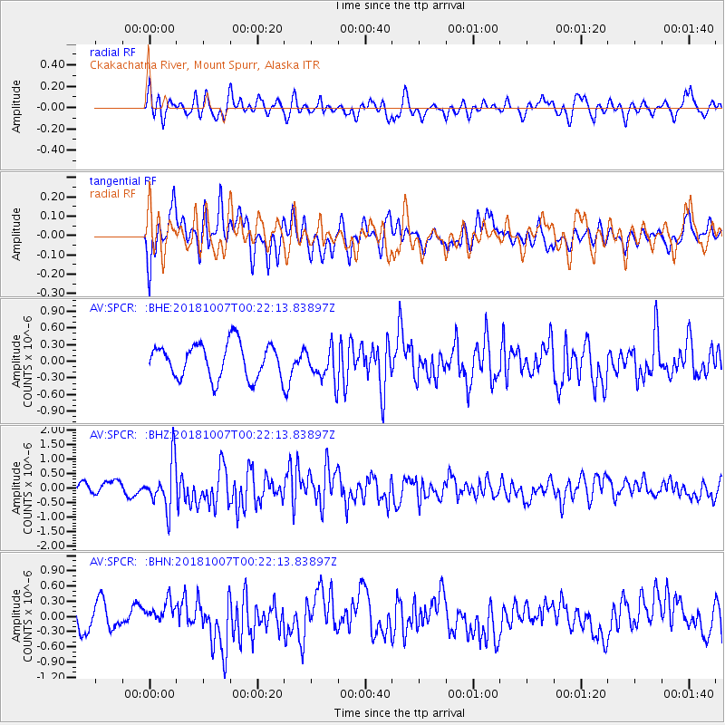
SPCR Ckakachatna River, Mount Spurr, Alaska - Earthquake Result Viewer
*The percent match for this event was below the threshold and hence no stack was calculated.
| Earthquake location: |
Haiti Region |
| Earthquake latitude/longitude: |
20.0/-73.0 |
| Earthquake time(UTC): |
2018/10/07 (280) 00:11:49 GMT |
| Earthquake Depth: |
12 km |
| Earthquake Magnitude: |
5.9 Mww |
| Earthquake Catalog/Contributor: |
NEIC PDE/us |
|
| Network: |
AV Alaska Volcano Observatory |
| Station: |
SPCR Ckakachatna River, Mount Spurr, Alaska |
| Lat/Lon: |
61.20 N/152.21 W |
| Elevation: |
984 m |
|
| Distance: |
67.5 deg |
| Az: |
329.002 deg |
| Baz: |
89.299 deg |
| Ray Param: |
$rayparam |
*The percent match for this event was below the threshold and hence was not used in the summary stack. |
|
| Radial Match: |
59.685753 % |
| Radial Bump: |
400 |
| Transverse Match: |
54.40906 % |
| Transverse Bump: |
400 |
| SOD ConfigId: |
13570011 |
| Insert Time: |
2019-05-01 10:15:22.126 +0000 |
| GWidth: |
2.5 |
| Max Bumps: |
400 |
| Tol: |
0.001 |
|
Signal To Noise
| Channel | StoN | STA | LTA |
| AV:SPCR: :BHZ:20181007T00:22:13.83897Z | 4.5633307 | 8.1625507E-7 | 1.7887265E-7 |
| AV:SPCR: :BHN:20181007T00:22:13.83897Z | 0.864977 | 2.3782925E-7 | 2.7495443E-7 |
| AV:SPCR: :BHE:20181007T00:22:13.83897Z | 1.0385518 | 3.2533717E-7 | 3.1326041E-7 |
| Arrivals |
| Ps | |
| PpPs | |
| PsPs/PpSs | |


