You are here: Home > Network List > CN - Canadian National Seismograph Network Stations List
> Station INK INUVIK, NT > Earthquake Result Viewer
INK INUVIK, NT - Earthquake Result Viewer
*The percent match for this event was below the threshold and hence no stack was calculated.
| Earthquake location: |
Haiti Region |
| Earthquake latitude/longitude: |
20.0/-73.0 |
| Earthquake time(UTC): |
2018/10/07 (280) 00:11:49 GMT |
| Earthquake Depth: |
12 km |
| Earthquake Magnitude: |
5.9 Mww |
| Earthquake Catalog/Contributor: |
NEIC PDE/us |
|
| Network: |
CN Canadian National Seismograph Network |
| Station: |
INK INUVIK, NT |
| Lat/Lon: |
68.31 N/133.53 W |
| Elevation: |
44 m |
|
| Distance: |
60.8 deg |
| Az: |
338.226 deg |
| Baz: |
110.276 deg |
| Ray Param: |
$rayparam |
*The percent match for this event was below the threshold and hence was not used in the summary stack. |
|
| Radial Match: |
56.229206 % |
| Radial Bump: |
400 |
| Transverse Match: |
54.933456 % |
| Transverse Bump: |
400 |
| SOD ConfigId: |
13570011 |
| Insert Time: |
2019-05-01 10:17:05.122 +0000 |
| GWidth: |
2.5 |
| Max Bumps: |
400 |
| Tol: |
0.001 |
|
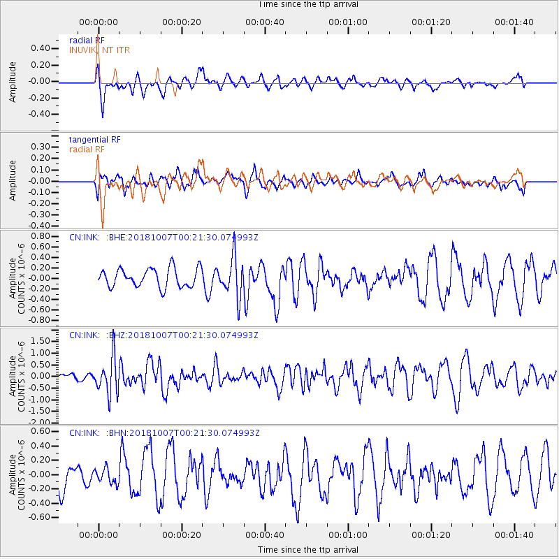
Signal To Noise
| Channel | StoN | STA | LTA |
| CN:INK: :BHZ:20181007T00:21:30.074993Z | 3.2117474 | 8.1484177E-7 | 2.5370667E-7 |
| CN:INK: :BHN:20181007T00:21:30.074993Z | 0.49600777 | 1.0557623E-7 | 2.1285197E-7 |
| CN:INK: :BHE:20181007T00:21:30.074993Z | 2.188388 | 3.8689873E-7 | 1.767962E-7 |
| Arrivals |
| Ps | |
| PpPs | |
| PsPs/PpSs | |


