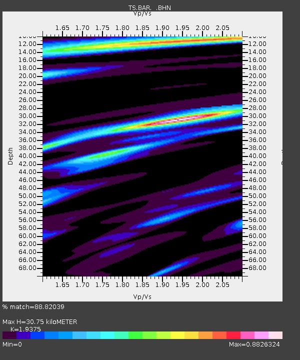
BAR Barrett Dam, California, USA - Earthquake Result Viewer
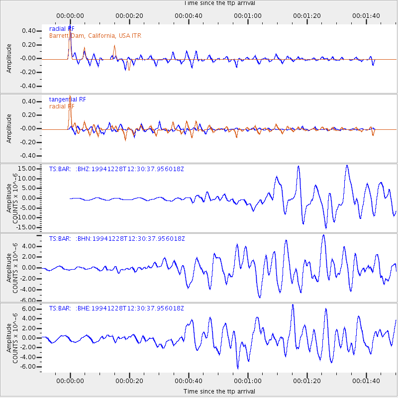
Earthquake location: Off East Coast Of Honshu, Japan
Earthquake latitude/longitude: 40.5/143.5
Earthquake time(UTC): 1994/12/28 (362) 12:19:23 GMT
Earthquake Depth: 33 km
Earthquake Magnitude: 6.4 MB, 7.5 MS, 7.2 UNKNOWN, 7.7 MW
Earthquake Catalog/Contributor: WHDF/NEIC
Network: TS TERRAscope (Southern California Seismic Network)
Station: BAR Barrett Dam, California, USA
Lat/Lon: 32.68 N/116.67 W
Elevation: 548 m
Distance: 76.3 deg
Az: 58.802 deg
Baz: 309.285 deg
Ray Param: 0.05106025
Estimated Moho Depth: 30.75 km
Estimated Crust Vp/Vs: 1.94
Assumed Crust Vp: 6.264 km/s
Estimated Crust Vs: 3.233 km/s
Estimated Crust Poisson's Ratio: 0.32
Radial Match: 88.82039 %
Radial Bump: 340
Transverse Match: 93.32373 %
Transverse Bump: 362
SOD ConfigId: 16938
Insert Time: 2010-02-26 13:57:40.998 +0000
GWidth: 2.5
Max Bumps: 400
Tol: 0.001

Signal To Noise

ChannelStoNSTALTA
TS:BAR: :BHN:19941228T12:30:37.956018Z0.841744242.0946916E-72.488513E-7
TS:BAR: :BHE:19941228T12:30:37.956018Z1.45174524.4150403E-73.041195E-7
TS:BAR: :BHZ:19941228T12:30:37.956018Z1.91125147.8914144E-74.1289252E-7
Arrivals
Ps4.7 SECOND
PpPs14 SECOND
PsPs/PpSs19 SECOND