You are here: Home > Network List > TA - USArray Transportable Network (new EarthScope stations) Stations List
> Station R17A Hanksville Airport, Hanksville, UT, USA > Earthquake Result Viewer
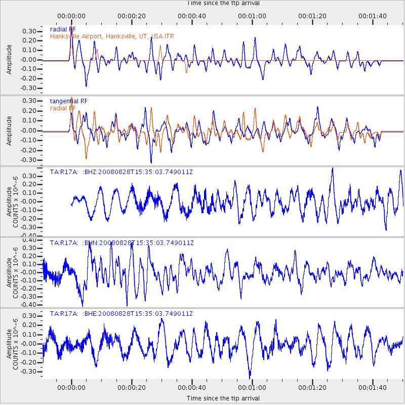
R17A Hanksville Airport, Hanksville, UT, USA - Earthquake Result Viewer
*The percent match for this event was below the threshold and hence no stack was calculated.
| Earthquake location: |
North Of Ascension Island |
| Earthquake latitude/longitude: |
-0.2/-17.4 |
| Earthquake time(UTC): |
2008/08/28 (241) 15:22:23 GMT |
| Earthquake Depth: |
15 km |
| Earthquake Magnitude: |
5.8 MB, 5.9 MS, 6.3 MW, 6.3 MW |
| Earthquake Catalog/Contributor: |
WHDF/NEIC |
|
| Network: |
TA USArray Transportable Network (new EarthScope stations) |
| Station: |
R17A Hanksville Airport, Hanksville, UT, USA |
| Lat/Lon: |
38.42 N/110.71 W |
| Elevation: |
1357 m |
|
| Distance: |
92.8 deg |
| Az: |
308.27 deg |
| Baz: |
88.117 deg |
| Ray Param: |
$rayparam |
*The percent match for this event was below the threshold and hence was not used in the summary stack. |
|
| Radial Match: |
55.16781 % |
| Radial Bump: |
397 |
| Transverse Match: |
69.40019 % |
| Transverse Bump: |
359 |
| SOD ConfigId: |
2504 |
| Insert Time: |
2010-03-06 16:29:33.004 +0000 |
| GWidth: |
2.5 |
| Max Bumps: |
400 |
| Tol: |
0.001 |
|
Signal To Noise
| Channel | StoN | STA | LTA |
| TA:R17A: :BHN:20080828T15:35:03.749011Z | 2.8915474 | 1.7945098E-7 | 6.2060536E-8 |
| TA:R17A: :BHE:20080828T15:35:03.749011Z | 0.6415062 | 4.400337E-8 | 6.8593835E-8 |
| TA:R17A: :BHZ:20080828T15:35:03.749011Z | 1.1919218 | 1.2375264E-7 | 1.03826146E-7 |
| Arrivals |
| Ps | |
| PpPs | |
| PsPs/PpSs | |


