You are here: Home > Network List > TA - USArray Transportable Network (new EarthScope stations) Stations List
> Station F21K Alatna River, AK, USA > Earthquake Result Viewer
F21K Alatna River, AK, USA - Earthquake Result Viewer
| Earthquake location: |
Haiti Region |
| Earthquake latitude/longitude: |
20.0/-73.0 |
| Earthquake time(UTC): |
2018/10/07 (280) 00:11:49 GMT |
| Earthquake Depth: |
12 km |
| Earthquake Magnitude: |
5.9 Mww |
| Earthquake Catalog/Contributor: |
NEIC PDE/us |
|
| Network: |
TA USArray Transportable Network (new EarthScope stations) |
| Station: |
F21K Alatna River, AK, USA |
| Lat/Lon: |
67.22 N/153.48 W |
| Elevation: |
597 m |
|
| Distance: |
68.0 deg |
| Az: |
335.536 deg |
| Baz: |
90.628 deg |
| Ray Param: |
0.056568306 |
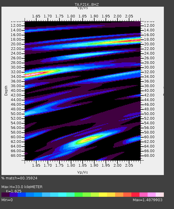
| Estimated Moho Depth: |
33.0 km |
| Estimated Crust Vp/Vs: |
1.62 |
| Assumed Crust Vp: |
6.455 km/s |
| Estimated Crust Vs: |
3.972 km/s |
| Estimated Crust Poisson's Ratio: |
0.20 |
|
| Radial Match: |
80.35924 % |
| Radial Bump: |
400 |
| Transverse Match: |
72.984406 % |
| Transverse Bump: |
400 |
| SOD ConfigId: |
13570011 |
| Insert Time: |
2019-05-01 10:20:03.727 +0000 |
| GWidth: |
2.5 |
| Max Bumps: |
400 |
| Tol: |
0.001 |
|

Signal To Noise
| Channel | StoN | STA | LTA |
| TA:F21K: :BHZ:20181007T00:22:17.350017Z | 5.741026 | 7.1529945E-7 | 1.2459437E-7 |
| TA:F21K: :BHN:20181007T00:22:17.350017Z | 0.6414032 | 8.249924E-8 | 1.2862306E-7 |
| TA:F21K: :BHE:20181007T00:22:17.350017Z | 1.7924379 | 2.5072947E-7 | 1.3988182E-7 |
| Arrivals |
| Ps | 3.3 SECOND |
| PpPs | 13 SECOND |
| PsPs/PpSs | 16 SECOND |


