You are here: Home > Network List > TA - USArray Transportable Network (new EarthScope stations) Stations List
> Station K16A Soda Springs, ID, USA > Earthquake Result Viewer
K16A Soda Springs, ID, USA - Earthquake Result Viewer
| Earthquake location: |
Southern Peru |
| Earthquake latitude/longitude: |
-16.0/-71.7 |
| Earthquake time(UTC): |
2008/07/08 (190) 09:13:07 GMT |
| Earthquake Depth: |
123 km |
| Earthquake Magnitude: |
5.8 MB, 6.2 MW, 6.2 MW |
| Earthquake Catalog/Contributor: |
WHDF/NEIC |
|
| Network: |
TA USArray Transportable Network (new EarthScope stations) |
| Station: |
K16A Soda Springs, ID, USA |
| Lat/Lon: |
42.83 N/111.59 W |
| Elevation: |
1885 m |
|
| Distance: |
69.0 deg |
| Az: |
329.688 deg |
| Baz: |
138.708 deg |
| Ray Param: |
0.05559216 |
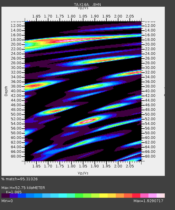
| Estimated Moho Depth: |
52.75 km |
| Estimated Crust Vp/Vs: |
1.87 |
| Assumed Crust Vp: |
6.207 km/s |
| Estimated Crust Vs: |
3.328 km/s |
| Estimated Crust Poisson's Ratio: |
0.30 |
|
| Radial Match: |
95.31026 % |
| Radial Bump: |
400 |
| Transverse Match: |
84.128395 % |
| Transverse Bump: |
400 |
| SOD ConfigId: |
2504 |
| Insert Time: |
2010-03-06 16:29:43.789 +0000 |
| GWidth: |
2.5 |
| Max Bumps: |
400 |
| Tol: |
0.001 |
|

Signal To Noise
| Channel | StoN | STA | LTA |
| TA:K16A: :BHN:20080708T09:23:28.949014Z | 9.164554 | 8.102958E-7 | 8.8416286E-8 |
| TA:K16A: :BHE:20080708T09:23:28.949014Z | 9.554657 | 7.67293E-7 | 8.0305654E-8 |
| TA:K16A: :BHZ:20080708T09:23:28.949014Z | 8.173591 | 9.246498E-7 | 1.1312651E-7 |
| Arrivals |
| Ps | 7.6 SECOND |
| PpPs | 24 SECOND |
| PsPs/PpSs | 31 SECOND |


