You are here: Home > Network List > TA - USArray Transportable Network (new EarthScope stations) Stations List
> Station G31M Satah River, YT, CAN > Earthquake Result Viewer
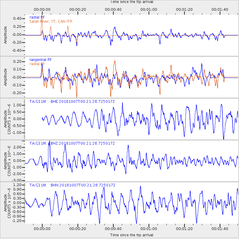
G31M Satah River, YT, CAN - Earthquake Result Viewer
*The percent match for this event was below the threshold and hence no stack was calculated.
| Earthquake location: |
Haiti Region |
| Earthquake latitude/longitude: |
20.0/-73.0 |
| Earthquake time(UTC): |
2018/10/07 (280) 00:11:49 GMT |
| Earthquake Depth: |
12 km |
| Earthquake Magnitude: |
5.9 Mww |
| Earthquake Catalog/Contributor: |
NEIC PDE/us |
|
| Network: |
TA USArray Transportable Network (new EarthScope stations) |
| Station: |
G31M Satah River, YT, CAN |
| Lat/Lon: |
66.92 N/134.27 W |
| Elevation: |
61 m |
|
| Distance: |
60.6 deg |
| Az: |
336.614 deg |
| Baz: |
108.798 deg |
| Ray Param: |
$rayparam |
*The percent match for this event was below the threshold and hence was not used in the summary stack. |
|
| Radial Match: |
65.81701 % |
| Radial Bump: |
400 |
| Transverse Match: |
60.974754 % |
| Transverse Bump: |
400 |
| SOD ConfigId: |
13570011 |
| Insert Time: |
2019-05-01 10:20:19.541 +0000 |
| GWidth: |
2.5 |
| Max Bumps: |
400 |
| Tol: |
0.001 |
|
Signal To Noise
| Channel | StoN | STA | LTA |
| TA:G31M: :BHZ:20181007T00:21:28.725017Z | 3.7568302 | 1.2150734E-6 | 3.234305E-7 |
| TA:G31M: :BHN:20181007T00:21:28.725017Z | 0.80266905 | 2.2069493E-7 | 2.7495133E-7 |
| TA:G31M: :BHE:20181007T00:21:28.725017Z | 1.7181308 | 4.699582E-7 | 2.7352877E-7 |
| Arrivals |
| Ps | |
| PpPs | |
| PsPs/PpSs | |


