You are here: Home > Network List > TA - USArray Transportable Network (new EarthScope stations) Stations List
> Station I28M Miner Creek, YT, CAN > Earthquake Result Viewer
I28M Miner Creek, YT, CAN - Earthquake Result Viewer
| Earthquake location: |
Haiti Region |
| Earthquake latitude/longitude: |
20.0/-73.0 |
| Earthquake time(UTC): |
2018/10/07 (280) 00:11:49 GMT |
| Earthquake Depth: |
12 km |
| Earthquake Magnitude: |
5.9 Mww |
| Earthquake Catalog/Contributor: |
NEIC PDE/us |
|
| Network: |
TA USArray Transportable Network (new EarthScope stations) |
| Station: |
I28M Miner Creek, YT, CAN |
| Lat/Lon: |
65.45 N/139.94 W |
| Elevation: |
1188 m |
|
| Distance: |
62.4 deg |
| Az: |
334.287 deg |
| Baz: |
102.509 deg |
| Ray Param: |
0.06024543 |
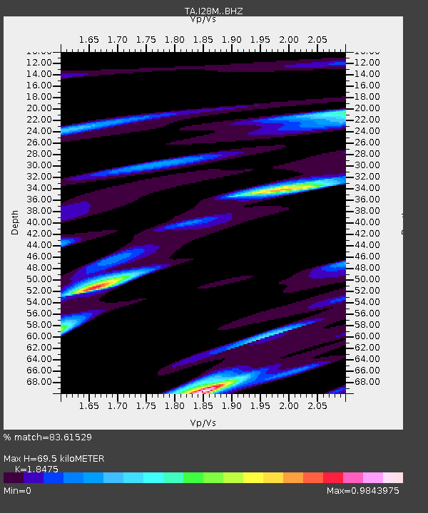
| Estimated Moho Depth: |
69.5 km |
| Estimated Crust Vp/Vs: |
1.85 |
| Assumed Crust Vp: |
6.566 km/s |
| Estimated Crust Vs: |
3.554 km/s |
| Estimated Crust Poisson's Ratio: |
0.29 |
|
| Radial Match: |
83.61529 % |
| Radial Bump: |
400 |
| Transverse Match: |
73.87084 % |
| Transverse Bump: |
400 |
| SOD ConfigId: |
13570011 |
| Insert Time: |
2019-05-01 10:20:33.587 +0000 |
| GWidth: |
2.5 |
| Max Bumps: |
400 |
| Tol: |
0.001 |
|

Signal To Noise
| Channel | StoN | STA | LTA |
| TA:I28M: :BHZ:20181007T00:21:40.949993Z | 3.2097962 | 1.0038823E-6 | 3.127558E-7 |
| TA:I28M: :BHN:20181007T00:21:40.949993Z | 1.3509848 | 2.2796773E-7 | 1.687419E-7 |
| TA:I28M: :BHE:20181007T00:21:40.949993Z | 1.238136 | 5.7570145E-7 | 4.6497428E-7 |
| Arrivals |
| Ps | 9.4 SECOND |
| PpPs | 29 SECOND |
| PsPs/PpSs | 38 SECOND |


