You are here: Home > Network List > TA - USArray Transportable Network (new EarthScope stations) Stations List
> Station I30M Mount Dempster, Yukon, CAN > Earthquake Result Viewer
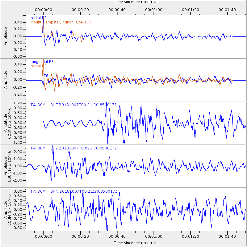
I30M Mount Dempster, Yukon, CAN - Earthquake Result Viewer
*The percent match for this event was below the threshold and hence no stack was calculated.
| Earthquake location: |
Haiti Region |
| Earthquake latitude/longitude: |
20.0/-73.0 |
| Earthquake time(UTC): |
2018/10/07 (280) 00:11:49 GMT |
| Earthquake Depth: |
12 km |
| Earthquake Magnitude: |
5.9 Mww |
| Earthquake Catalog/Contributor: |
NEIC PDE/us |
|
| Network: |
TA USArray Transportable Network (new EarthScope stations) |
| Station: |
I30M Mount Dempster, Yukon, CAN |
| Lat/Lon: |
65.22 N/136.38 W |
| Elevation: |
1399 m |
|
| Distance: |
60.9 deg |
| Az: |
334.453 deg |
| Baz: |
105.818 deg |
| Ray Param: |
$rayparam |
*The percent match for this event was below the threshold and hence was not used in the summary stack. |
|
| Radial Match: |
76.37324 % |
| Radial Bump: |
400 |
| Transverse Match: |
66.63225 % |
| Transverse Bump: |
400 |
| SOD ConfigId: |
13570011 |
| Insert Time: |
2019-05-01 10:20:36.218 +0000 |
| GWidth: |
2.5 |
| Max Bumps: |
400 |
| Tol: |
0.001 |
|
Signal To Noise
| Channel | StoN | STA | LTA |
| TA:I30M: :BHZ:20181007T00:21:30.850017Z | 4.0679193 | 8.4655437E-7 | 2.0810502E-7 |
| TA:I30M: :BHN:20181007T00:21:30.850017Z | 1.0344514 | 2.7943852E-7 | 2.7013212E-7 |
| TA:I30M: :BHE:20181007T00:21:30.850017Z | 3.6096764 | 4.6675677E-7 | 1.293071E-7 |
| Arrivals |
| Ps | |
| PpPs | |
| PsPs/PpSs | |


