You are here: Home > Network List > TA - USArray Transportable Network (new EarthScope stations) Stations List
> Station J20K Nowitna River, AK, USA > Earthquake Result Viewer
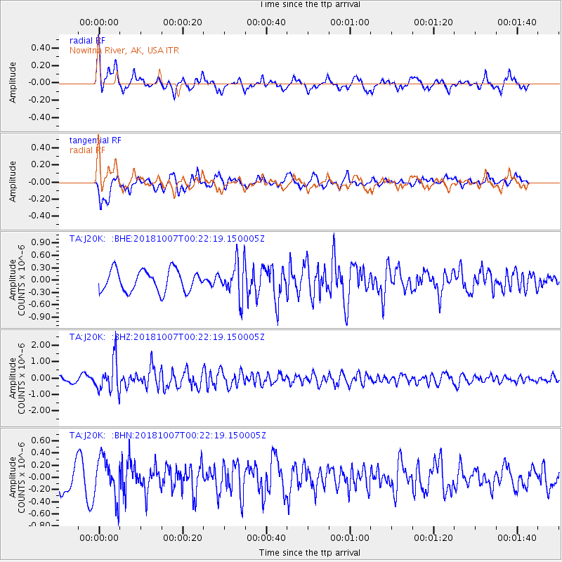
J20K Nowitna River, AK, USA - Earthquake Result Viewer
*The percent match for this event was below the threshold and hence no stack was calculated.
| Earthquake location: |
Haiti Region |
| Earthquake latitude/longitude: |
20.0/-73.0 |
| Earthquake time(UTC): |
2018/10/07 (280) 00:11:49 GMT |
| Earthquake Depth: |
12 km |
| Earthquake Magnitude: |
5.9 Mww |
| Earthquake Catalog/Contributor: |
NEIC PDE/us |
|
| Network: |
TA USArray Transportable Network (new EarthScope stations) |
| Station: |
J20K Nowitna River, AK, USA |
| Lat/Lon: |
64.18 N/154.15 W |
| Elevation: |
314 m |
|
| Distance: |
68.3 deg |
| Az: |
332.242 deg |
| Baz: |
88.799 deg |
| Ray Param: |
$rayparam |
*The percent match for this event was below the threshold and hence was not used in the summary stack. |
|
| Radial Match: |
77.604836 % |
| Radial Bump: |
400 |
| Transverse Match: |
71.671455 % |
| Transverse Bump: |
400 |
| SOD ConfigId: |
13570011 |
| Insert Time: |
2019-05-01 10:20:40.560 +0000 |
| GWidth: |
2.5 |
| Max Bumps: |
400 |
| Tol: |
0.001 |
|
Signal To Noise
| Channel | StoN | STA | LTA |
| TA:J20K: :BHZ:20181007T00:22:19.150005Z | 7.327536 | 1.0072997E-6 | 1.3746772E-7 |
| TA:J20K: :BHN:20181007T00:22:19.150005Z | 1.9447486 | 3.297207E-7 | 1.6954412E-7 |
| TA:J20K: :BHE:20181007T00:22:19.150005Z | 1.7616961 | 4.5429874E-7 | 2.5787577E-7 |
| Arrivals |
| Ps | |
| PpPs | |
| PsPs/PpSs | |


