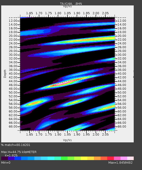
K16A Soda Springs, ID, USA - Earthquake Result Viewer

Earthquake location: Lake Baykal Region, Russia
Earthquake latitude/longitude: 51.6/104.2
Earthquake time(UTC): 2008/08/27 (240) 01:35:32 GMT
Earthquake Depth: 16 km
Earthquake Magnitude: 5.8 MB, 6.2 MS, 6.2 MW, 6.2 MW
Earthquake Catalog/Contributor: WHDF/NEIC
Network: TA USArray Transportable Network (new EarthScope stations)
Station: K16A Soda Springs, ID, USA
Lat/Lon: 42.83 N/111.59 W
Elevation: 1885 m
Distance: 81.0 deg
Az: 25.796 deg
Baz: 338.352 deg
Ray Param: 0.047915436
Estimated Moho Depth: 44.75 km
Estimated Crust Vp/Vs: 1.83
Assumed Crust Vp: 6.207 km/s
Estimated Crust Vs: 3.401 km/s
Estimated Crust Poisson's Ratio: 0.29
Radial Match: 80.16201 %
Radial Bump: 400
Transverse Match: 65.13751 %
Transverse Bump: 400
SOD ConfigId: 2504
Insert Time: 2010-03-06 16:30:04.237 +0000
GWidth: 2.5
Max Bumps: 400
Tol: 0.001

Signal To Noise

ChannelStoNSTALTA
TA:K16A: :BHN:20080827T01:47:14.300024Z5.6653834.7583416E-78.398976E-8
TA:K16A: :BHE:20080827T01:47:14.300024Z2.55560562.3982534E-79.384286E-8
TA:K16A: :BHZ:20080827T01:47:14.300024Z1.70105221.3230513E-77.777841E-8
Arrivals
Ps6.1 SECOND
PpPs20 SECOND
PsPs/PpSs26 SECOND