You are here: Home > Network List > TA - USArray Transportable Network (new EarthScope stations) Stations List
> Station K16A Soda Springs, ID, USA > Earthquake Result Viewer
K16A Soda Springs, ID, USA - Earthquake Result Viewer
| Earthquake location: |
Hokkaido, Japan Region |
| Earthquake latitude/longitude: |
41.9/143.8 |
| Earthquake time(UTC): |
2008/09/11 (255) 00:20:50 GMT |
| Earthquake Depth: |
25 km |
| Earthquake Magnitude: |
6.1 MB, 7.0 MS, 6.8 MW, 6.8 MW |
| Earthquake Catalog/Contributor: |
WHDF/NEIC |
|
| Network: |
TA USArray Transportable Network (new EarthScope stations) |
| Station: |
K16A Soda Springs, ID, USA |
| Lat/Lon: |
42.83 N/111.59 W |
| Elevation: |
1885 m |
|
| Distance: |
71.8 deg |
| Az: |
48.502 deg |
| Baz: |
310.519 deg |
| Ray Param: |
0.054027405 |
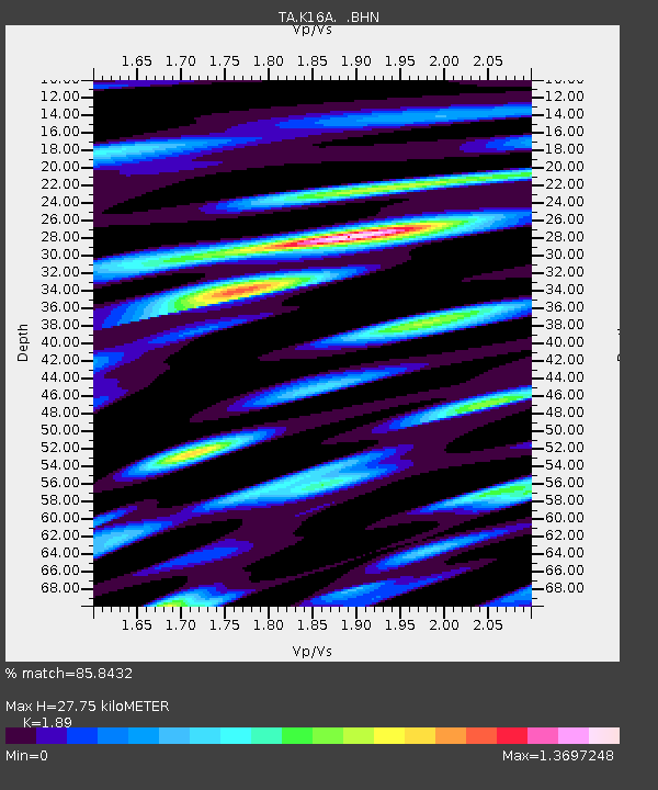
| Estimated Moho Depth: |
27.75 km |
| Estimated Crust Vp/Vs: |
1.89 |
| Assumed Crust Vp: |
6.207 km/s |
| Estimated Crust Vs: |
3.284 km/s |
| Estimated Crust Poisson's Ratio: |
0.31 |
|
| Radial Match: |
85.8432 % |
| Radial Bump: |
400 |
| Transverse Match: |
82.38862 % |
| Transverse Bump: |
400 |
| SOD ConfigId: |
2560 |
| Insert Time: |
2010-03-06 16:30:13.401 +0000 |
| GWidth: |
2.5 |
| Max Bumps: |
400 |
| Tol: |
0.001 |
|

Signal To Noise
| Channel | StoN | STA | LTA |
| TA:K16A: :BHN:20080911T00:31:40.349016Z | 2.4684916 | 8.134017E-7 | 3.2951368E-7 |
| TA:K16A: :BHE:20080911T00:31:40.349016Z | 1.4832294 | 4.2718443E-7 | 2.880097E-7 |
| TA:K16A: :BHZ:20080911T00:31:40.349016Z | 1.8984208 | 6.146881E-7 | 3.2378915E-7 |
| Arrivals |
| Ps | 4.1 SECOND |
| PpPs | 13 SECOND |
| PsPs/PpSs | 17 SECOND |


