You are here: Home > Network List > TA - USArray Transportable Network (new EarthScope stations) Stations List
> Station K16A Soda Springs, ID, USA > Earthquake Result Viewer
K16A Soda Springs, ID, USA - Earthquake Result Viewer
| Earthquake location: |
Windward Islands |
| Earthquake latitude/longitude: |
15.0/-61.3 |
| Earthquake time(UTC): |
2007/11/29 (333) 19:00:19 GMT |
| Earthquake Depth: |
148 km |
| Earthquake Magnitude: |
6.9 MB, 7.4 MW, 7.4 MW |
| Earthquake Catalog/Contributor: |
WHDF/NEIC |
|
| Network: |
TA USArray Transportable Network (new EarthScope stations) |
| Station: |
K16A Soda Springs, ID, USA |
| Lat/Lon: |
42.83 N/111.59 W |
| Elevation: |
1885 m |
|
| Distance: |
51.1 deg |
| Az: |
313.33 deg |
| Baz: |
107.118 deg |
| Ray Param: |
0.067117035 |
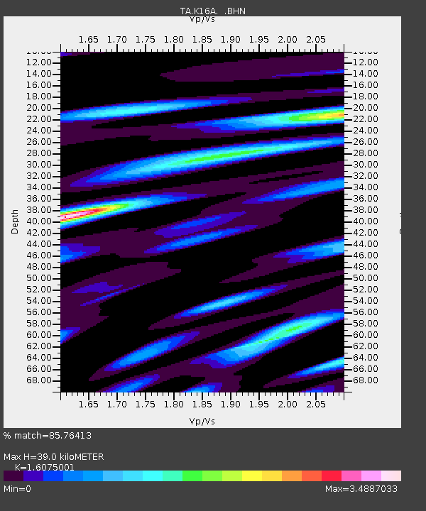
| Estimated Moho Depth: |
39.0 km |
| Estimated Crust Vp/Vs: |
1.61 |
| Assumed Crust Vp: |
6.207 km/s |
| Estimated Crust Vs: |
3.861 km/s |
| Estimated Crust Poisson's Ratio: |
0.18 |
|
| Radial Match: |
85.76413 % |
| Radial Bump: |
400 |
| Transverse Match: |
85.770256 % |
| Transverse Bump: |
400 |
| SOD ConfigId: |
2564 |
| Insert Time: |
2010-03-06 16:30:33.649 +0000 |
| GWidth: |
2.5 |
| Max Bumps: |
400 |
| Tol: |
0.001 |
|

Signal To Noise
| Channel | StoN | STA | LTA |
| TA:K16A: :BHN:20071129T19:08:36.650Z | 19.83974 | 5.5591295E-6 | 2.802017E-7 |
| TA:K16A: :BHE:20071129T19:08:36.650Z | 32.480316 | 1.2830399E-5 | 3.9502078E-7 |
| TA:K16A: :BHZ:20071129T19:08:36.650Z | 40.675854 | 1.3009161E-5 | 3.1982518E-7 |
| Arrivals |
| Ps | 4.0 SECOND |
| PpPs | 15 SECOND |
| PsPs/PpSs | 20 SECOND |


