You are here: Home > Network List > TA - USArray Transportable Network (new EarthScope stations) Stations List
> Station K16A Soda Springs, ID, USA > Earthquake Result Viewer
K16A Soda Springs, ID, USA - Earthquake Result Viewer
| Earthquake location: |
Near Coast Of Peru |
| Earthquake latitude/longitude: |
-13.4/-76.6 |
| Earthquake time(UTC): |
2007/08/15 (227) 23:40:57 GMT |
| Earthquake Depth: |
39 km |
| Earthquake Magnitude: |
6.7 MB, 7.9 MS, 8.0 MW, 7.5 ME |
| Earthquake Catalog/Contributor: |
WHDF/NEIC |
|
| Network: |
TA USArray Transportable Network (new EarthScope stations) |
| Station: |
K16A Soda Springs, ID, USA |
| Lat/Lon: |
42.83 N/111.59 W |
| Elevation: |
1885 m |
|
| Distance: |
64.5 deg |
| Az: |
332.138 deg |
| Baz: |
141.81 deg |
| Ray Param: |
0.058820326 |
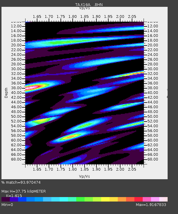
| Estimated Moho Depth: |
37.75 km |
| Estimated Crust Vp/Vs: |
1.62 |
| Assumed Crust Vp: |
6.207 km/s |
| Estimated Crust Vs: |
3.843 km/s |
| Estimated Crust Poisson's Ratio: |
0.19 |
|
| Radial Match: |
93.970474 % |
| Radial Bump: |
400 |
| Transverse Match: |
91.546684 % |
| Transverse Bump: |
400 |
| SOD ConfigId: |
2564 |
| Insert Time: |
2010-03-06 16:30:51.178 +0000 |
| GWidth: |
2.5 |
| Max Bumps: |
400 |
| Tol: |
0.001 |
|

Signal To Noise
| Channel | StoN | STA | LTA |
| TA:K16A: :BHN:20070815T23:50:59.79802Z | 11.830653 | 1.4051104E-6 | 1.18768625E-7 |
| TA:K16A: :BHE:20070815T23:50:59.79802Z | 10.646869 | 1.434559E-6 | 1.3473998E-7 |
| TA:K16A: :BHZ:20070815T23:50:59.79802Z | 25.51174 | 3.438732E-6 | 1.3479018E-7 |
| Arrivals |
| Ps | 3.9 SECOND |
| PpPs | 15 SECOND |
| PsPs/PpSs | 19 SECOND |


