You are here: Home > Network List > TA - USArray Transportable Network (new EarthScope stations) Stations List
> Station K16A Soda Springs, ID, USA > Earthquake Result Viewer
K16A Soda Springs, ID, USA - Earthquake Result Viewer
| Earthquake location: |
Vanuatu Islands |
| Earthquake latitude/longitude: |
-15.6/167.7 |
| Earthquake time(UTC): |
2007/08/01 (213) 17:08:51 GMT |
| Earthquake Depth: |
120 km |
| Earthquake Magnitude: |
6.2 MB, 7.2 MW, 7.2 MW |
| Earthquake Catalog/Contributor: |
WHDF/NEIC |
|
| Network: |
TA USArray Transportable Network (new EarthScope stations) |
| Station: |
K16A Soda Springs, ID, USA |
| Lat/Lon: |
42.83 N/111.59 W |
| Elevation: |
1885 m |
|
| Distance: |
93.8 deg |
| Az: |
46.689 deg |
| Baz: |
252.402 deg |
| Ray Param: |
0.041107345 |
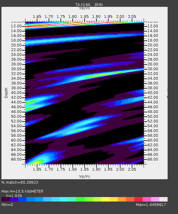
| Estimated Moho Depth: |
10.5 km |
| Estimated Crust Vp/Vs: |
1.84 |
| Assumed Crust Vp: |
6.207 km/s |
| Estimated Crust Vs: |
3.382 km/s |
| Estimated Crust Poisson's Ratio: |
0.29 |
|
| Radial Match: |
90.28923 % |
| Radial Bump: |
400 |
| Transverse Match: |
85.2522 % |
| Transverse Bump: |
400 |
| SOD ConfigId: |
2564 |
| Insert Time: |
2010-03-06 16:30:58.228 +0000 |
| GWidth: |
2.5 |
| Max Bumps: |
400 |
| Tol: |
0.001 |
|

Signal To Noise
| Channel | StoN | STA | LTA |
| TA:K16A: :BHN:20070801T17:21:23.775Z | 0.9610385 | 8.885439E-8 | 9.2456645E-8 |
| TA:K16A: :BHE:20070801T17:21:23.775Z | 1.4735935 | 1.6790646E-7 | 1.1394355E-7 |
| TA:K16A: :BHZ:20070801T17:21:23.775Z | 2.577557 | 2.7827784E-7 | 1.0796185E-7 |
| Arrivals |
| Ps | 1.4 SECOND |
| PpPs | 4.7 SECOND |
| PsPs/PpSs | 6.1 SECOND |


