You are here: Home > Network List > TA - USArray Transportable Network (new EarthScope stations) Stations List
> Station F26K Sheenjek River, AK, USA > Earthquake Result Viewer
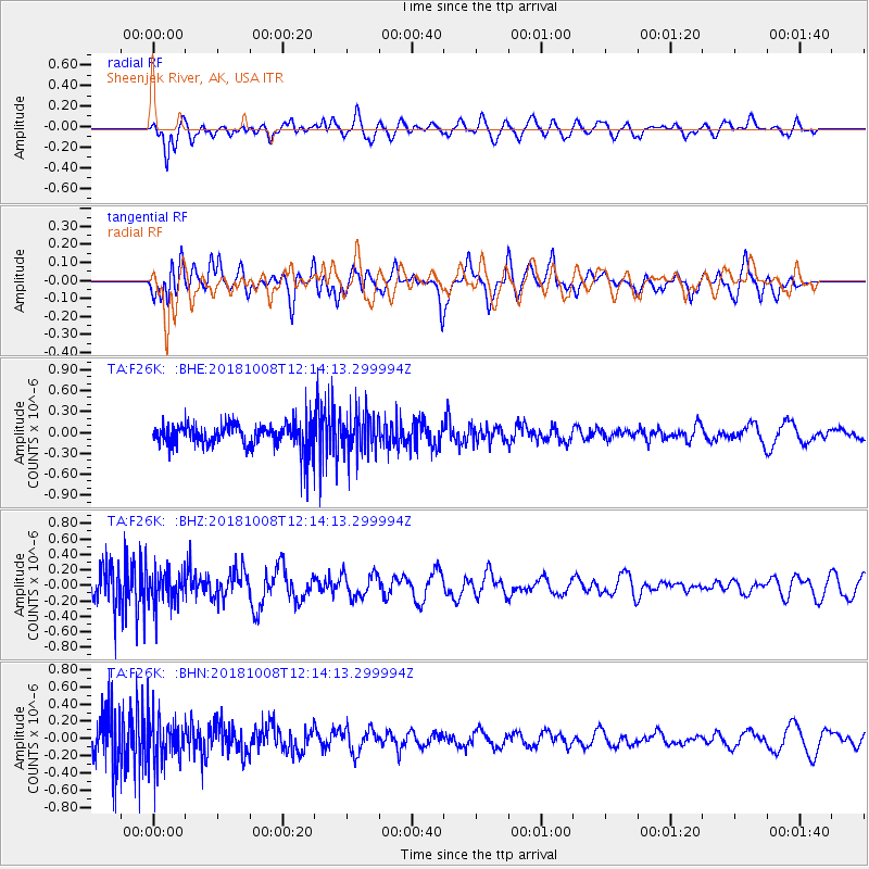
F26K Sheenjek River, AK, USA - Earthquake Result Viewer
*The percent match for this event was below the threshold and hence no stack was calculated.
| Earthquake location: |
Gulf Of California |
| Earthquake latitude/longitude: |
23.6/-108.9 |
| Earthquake time(UTC): |
2018/10/08 (281) 12:05:56 GMT |
| Earthquake Depth: |
7.0 km |
| Earthquake Magnitude: |
5.5 Mww |
| Earthquake Catalog/Contributor: |
NEIC PDE/us |
|
| Network: |
TA USArray Transportable Network (new EarthScope stations) |
| Station: |
F26K Sheenjek River, AK, USA |
| Lat/Lon: |
67.69 N/144.15 W |
| Elevation: |
683 m |
|
| Distance: |
49.1 deg |
| Az: |
343.075 deg |
| Baz: |
135.62 deg |
| Ray Param: |
$rayparam |
*The percent match for this event was below the threshold and hence was not used in the summary stack. |
|
| Radial Match: |
52.36852 % |
| Radial Bump: |
400 |
| Transverse Match: |
63.090515 % |
| Transverse Bump: |
400 |
| SOD ConfigId: |
13570011 |
| Insert Time: |
2019-05-01 10:37:19.729 +0000 |
| GWidth: |
2.5 |
| Max Bumps: |
400 |
| Tol: |
0.001 |
|
Signal To Noise
| Channel | StoN | STA | LTA |
| TA:F26K: :BHZ:20181008T12:14:13.299994Z | 1.161057 | 2.1304731E-7 | 1.834943E-7 |
| TA:F26K: :BHN:20181008T12:14:13.299994Z | 1.3049324 | 2.6169306E-7 | 2.0054148E-7 |
| TA:F26K: :BHE:20181008T12:14:13.299994Z | 1.6175675 | 2.894325E-7 | 1.7893072E-7 |
| Arrivals |
| Ps | |
| PpPs | |
| PsPs/PpSs | |


