You are here: Home > Network List > TA - USArray Transportable Network (new EarthScope stations) Stations List
> Station O17K Koliganek, Bristol Bay, AK, USA > Earthquake Result Viewer
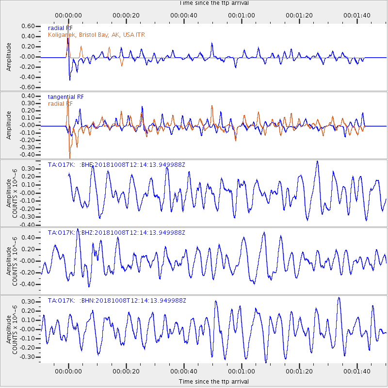
O17K Koliganek, Bristol Bay, AK, USA - Earthquake Result Viewer
*The percent match for this event was below the threshold and hence no stack was calculated.
| Earthquake location: |
Gulf Of California |
| Earthquake latitude/longitude: |
23.6/-108.9 |
| Earthquake time(UTC): |
2018/10/08 (281) 12:05:56 GMT |
| Earthquake Depth: |
7.0 km |
| Earthquake Magnitude: |
5.5 Mww |
| Earthquake Catalog/Contributor: |
NEIC PDE/us |
|
| Network: |
TA USArray Transportable Network (new EarthScope stations) |
| Station: |
O17K Koliganek, Bristol Bay, AK, USA |
| Lat/Lon: |
59.77 N/157.09 W |
| Elevation: |
156 m |
|
| Distance: |
49.2 deg |
| Az: |
330.138 deg |
| Baz: |
115.504 deg |
| Ray Param: |
$rayparam |
*The percent match for this event was below the threshold and hence was not used in the summary stack. |
|
| Radial Match: |
53.402573 % |
| Radial Bump: |
400 |
| Transverse Match: |
61.12957 % |
| Transverse Bump: |
400 |
| SOD ConfigId: |
13570011 |
| Insert Time: |
2019-05-01 10:37:40.832 +0000 |
| GWidth: |
2.5 |
| Max Bumps: |
400 |
| Tol: |
0.001 |
|
Signal To Noise
| Channel | StoN | STA | LTA |
| TA:O17K: :BHZ:20181008T12:14:13.949988Z | 2.7936945 | 2.8967872E-7 | 1.036902E-7 |
| TA:O17K: :BHN:20181008T12:14:13.949988Z | 1.5352477 | 1.125581E-7 | 7.331592E-8 |
| TA:O17K: :BHE:20181008T12:14:13.949988Z | 1.0273925 | 1.5824563E-7 | 1.5402647E-7 |
| Arrivals |
| Ps | |
| PpPs | |
| PsPs/PpSs | |


