You are here: Home > Network List > CI - Caltech Regional Seismic Network Stations List
> Station SMM Simmler, CA, USA > Earthquake Result Viewer
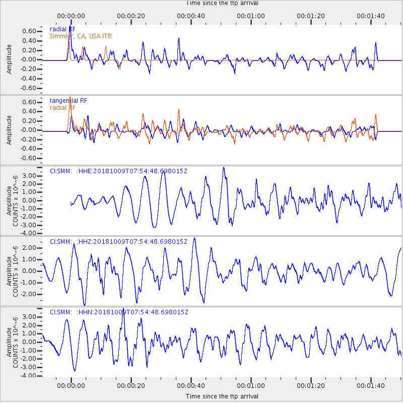
SMM Simmler, CA, USA - Earthquake Result Viewer
*The percent match for this event was below the threshold and hence no stack was calculated.
| Earthquake location: |
Kuril Islands |
| Earthquake latitude/longitude: |
49.4/156.2 |
| Earthquake time(UTC): |
2018/10/09 (282) 07:45:14 GMT |
| Earthquake Depth: |
42 km |
| Earthquake Magnitude: |
6.0 Mww |
| Earthquake Catalog/Contributor: |
NEIC PDE/us |
|
| Network: |
CI Caltech Regional Seismic Network |
| Station: |
SMM Simmler, CA, USA |
| Lat/Lon: |
35.31 N/120.00 W |
| Elevation: |
599 m |
|
| Distance: |
60.4 deg |
| Az: |
69.18 deg |
| Baz: |
311.737 deg |
| Ray Param: |
$rayparam |
*The percent match for this event was below the threshold and hence was not used in the summary stack. |
|
| Radial Match: |
47.043957 % |
| Radial Bump: |
400 |
| Transverse Match: |
57.699448 % |
| Transverse Bump: |
400 |
| SOD ConfigId: |
13570011 |
| Insert Time: |
2019-05-01 10:41:49.595 +0000 |
| GWidth: |
2.5 |
| Max Bumps: |
400 |
| Tol: |
0.001 |
|
Signal To Noise
| Channel | StoN | STA | LTA |
| CI:SMM: :HHZ:20181009T07:54:48.698015Z | 3.5644166 | 1.6104747E-6 | 4.5182E-7 |
| CI:SMM: :HHN:20181009T07:54:48.698015Z | 2.8909342 | 2.0509033E-6 | 7.094258E-7 |
| CI:SMM: :HHE:20181009T07:54:48.698015Z | 1.9175869 | 2.2441898E-6 | 1.1703197E-6 |
| Arrivals |
| Ps | |
| PpPs | |
| PsPs/PpSs | |


