You are here: Home > Network List > US - United States National Seismic Network Stations List
> Station EGMT Eagleton, Montana, USA > Earthquake Result Viewer
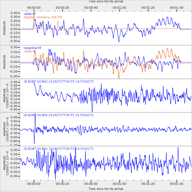
EGMT Eagleton, Montana, USA - Earthquake Result Viewer
*The percent match for this event was below the threshold and hence no stack was calculated.
| Earthquake location: |
Chile-Argentina Border Region |
| Earthquake latitude/longitude: |
-24.3/-67.9 |
| Earthquake time(UTC): |
2016/07/27 (209) 06:43:45 GMT |
| Earthquake Depth: |
99 km |
| Earthquake Magnitude: |
5.6 MB |
| Earthquake Catalog/Contributor: |
NEIC PDE/NEIC COMCAT |
|
| Network: |
US United States National Seismic Network |
| Station: |
EGMT Eagleton, Montana, USA |
| Lat/Lon: |
48.02 N/109.75 W |
| Elevation: |
1055 m |
|
| Distance: |
81.2 deg |
| Az: |
333.028 deg |
| Baz: |
141.935 deg |
| Ray Param: |
$rayparam |
*The percent match for this event was below the threshold and hence was not used in the summary stack. |
|
| Radial Match: |
33.54717 % |
| Radial Bump: |
400 |
| Transverse Match: |
51.28961 % |
| Transverse Bump: |
400 |
| SOD ConfigId: |
1634031 |
| Insert Time: |
2016-08-10 06:47:15.534 +0000 |
| GWidth: |
2.5 |
| Max Bumps: |
400 |
| Tol: |
0.001 |
|
Signal To Noise
| Channel | StoN | STA | LTA |
| US:EGMT:00:BHZ:20160727T06:55:19.550027Z | 6.390025 | 3.849776E-7 | 6.024665E-8 |
| US:EGMT:00:BH1:20160727T06:55:19.550027Z | 1.5071023 | 1.8446337E-7 | 1.2239606E-7 |
| US:EGMT:00:BH2:20160727T06:55:19.550027Z | 0.95612544 | 1.11345706E-7 | 1.1645512E-7 |
| Arrivals |
| Ps | |
| PpPs | |
| PsPs/PpSs | |


