You are here: Home > Network List > LD - Lamont-Doherty Cooperative Seismographic Network Stations List
> Station GEDE Greenville, DE, USA > Earthquake Result Viewer
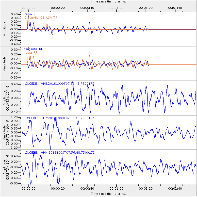
GEDE Greenville, DE, USA - Earthquake Result Viewer
*The percent match for this event was below the threshold and hence no stack was calculated.
| Earthquake location: |
Kuril Islands |
| Earthquake latitude/longitude: |
49.4/156.2 |
| Earthquake time(UTC): |
2018/10/09 (282) 07:45:14 GMT |
| Earthquake Depth: |
42 km |
| Earthquake Magnitude: |
6.0 Mww |
| Earthquake Catalog/Contributor: |
NEIC PDE/us |
|
| Network: |
LD Lamont-Doherty Cooperative Seismographic Network |
| Station: |
GEDE Greenville, DE, USA |
| Lat/Lon: |
39.81 N/75.64 W |
| Elevation: |
105 m |
|
| Distance: |
80.1 deg |
| Az: |
37.918 deg |
| Baz: |
328.608 deg |
| Ray Param: |
$rayparam |
*The percent match for this event was below the threshold and hence was not used in the summary stack. |
|
| Radial Match: |
69.44351 % |
| Radial Bump: |
400 |
| Transverse Match: |
37.987923 % |
| Transverse Bump: |
400 |
| SOD ConfigId: |
13570011 |
| Insert Time: |
2019-05-01 10:44:37.297 +0000 |
| GWidth: |
2.5 |
| Max Bumps: |
400 |
| Tol: |
0.001 |
|
Signal To Noise
| Channel | StoN | STA | LTA |
| LD:GEDE: :HHZ:20181009T07:56:48.750017Z | 7.1910224 | 7.215877E-7 | 1.0034563E-7 |
| LD:GEDE: :HHN:20181009T07:56:48.750017Z | 2.8126183 | 3.7956403E-7 | 1.3495043E-7 |
| LD:GEDE: :HHE:20181009T07:56:48.750017Z | 1.6839889 | 2.0375951E-7 | 1.2099814E-7 |
| Arrivals |
| Ps | |
| PpPs | |
| PsPs/PpSs | |


