You are here: Home > Network List > MM - Myanmar National Seismic Network Stations List
> Station TGI Taung Gyi, Myanmar > Earthquake Result Viewer
TGI Taung Gyi, Myanmar - Earthquake Result Viewer
| Earthquake location: |
Kuril Islands |
| Earthquake latitude/longitude: |
49.4/156.2 |
| Earthquake time(UTC): |
2018/10/09 (282) 07:45:14 GMT |
| Earthquake Depth: |
42 km |
| Earthquake Magnitude: |
6.0 Mww |
| Earthquake Catalog/Contributor: |
NEIC PDE/us |
|
| Network: |
MM Myanmar National Seismic Network |
| Station: |
TGI Taung Gyi, Myanmar |
| Lat/Lon: |
20.77 N/97.03 E |
| Elevation: |
1458 m |
|
| Distance: |
54.5 deg |
| Az: |
260.566 deg |
| Baz: |
43.492 deg |
| Ray Param: |
0.065310456 |
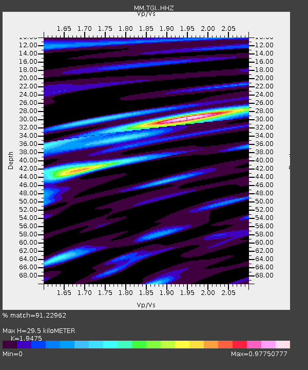
| Estimated Moho Depth: |
29.5 km |
| Estimated Crust Vp/Vs: |
1.95 |
| Assumed Crust Vp: |
6.316 km/s |
| Estimated Crust Vs: |
3.243 km/s |
| Estimated Crust Poisson's Ratio: |
0.32 |
|
| Radial Match: |
91.22962 % |
| Radial Bump: |
293 |
| Transverse Match: |
82.50045 % |
| Transverse Bump: |
400 |
| SOD ConfigId: |
13570011 |
| Insert Time: |
2019-05-01 10:45:01.249 +0000 |
| GWidth: |
2.5 |
| Max Bumps: |
400 |
| Tol: |
0.001 |
|

Signal To Noise
| Channel | StoN | STA | LTA |
| MM:TGI: :HHZ:20181009T07:54:07.43001Z | 89.40644 | 3.3054648E-6 | 3.6971215E-8 |
| MM:TGI: :HHN:20181009T07:54:07.43001Z | 28.333723 | 1.2614933E-6 | 4.452268E-8 |
| MM:TGI: :HHE:20181009T07:54:07.43001Z | 13.806949 | 8.1498104E-7 | 5.9026878E-8 |
| Arrivals |
| Ps | 4.6 SECOND |
| PpPs | 13 SECOND |
| PsPs/PpSs | 18 SECOND |


