You are here: Home > Network List > TS - TERRAscope (Southern California Seismic Network) Stations List
> Station BAR Barrett Dam, California, USA > Earthquake Result Viewer
BAR Barrett Dam, California, USA - Earthquake Result Viewer
| Earthquake location: |
Tonga Islands |
| Earthquake latitude/longitude: |
-20.0/-175.9 |
| Earthquake time(UTC): |
1995/10/06 (279) 11:39:36 GMT |
| Earthquake Depth: |
209 km |
| Earthquake Magnitude: |
5.7 MB, 6.4 UNKNOWN, 6.3 MW |
| Earthquake Catalog/Contributor: |
WHDF/NEIC |
|
| Network: |
TS TERRAscope (Southern California Seismic Network) |
| Station: |
BAR Barrett Dam, California, USA |
| Lat/Lon: |
32.68 N/116.67 W |
| Elevation: |
548 m |
|
| Distance: |
77.1 deg |
| Az: |
48.023 deg |
| Baz: |
235.985 deg |
| Ray Param: |
0.04998138 |
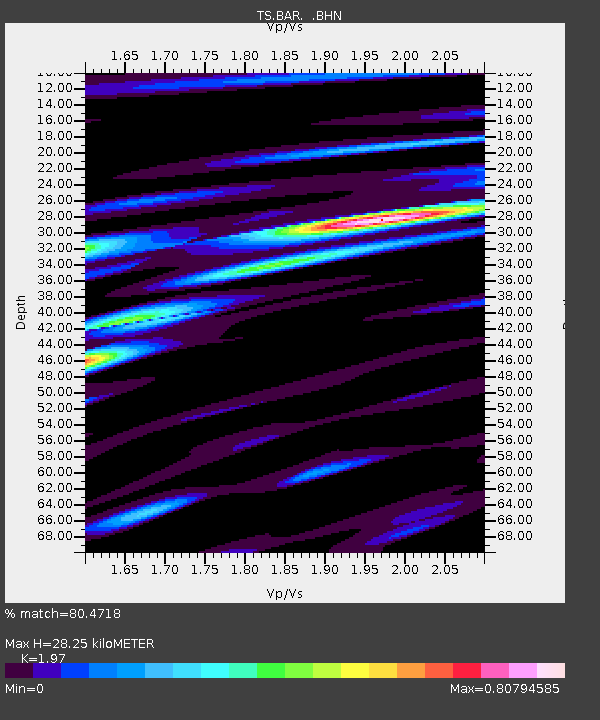
| Estimated Moho Depth: |
28.25 km |
| Estimated Crust Vp/Vs: |
1.97 |
| Assumed Crust Vp: |
6.264 km/s |
| Estimated Crust Vs: |
3.18 km/s |
| Estimated Crust Poisson's Ratio: |
0.33 |
|
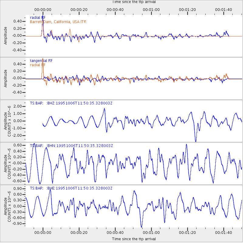
| Radial Match: |
80.4718 % |
| Radial Bump: |
400 |
| Transverse Match: |
53.935913 % |
| Transverse Bump: |
400 |
| SOD ConfigId: |
6273 |
| Insert Time: |
2010-02-26 13:57:49.988 +0000 |
| GWidth: |
2.5 |
| Max Bumps: |
400 |
| Tol: |
0.001 |
|
Signal To Noise
| Channel | StoN | STA | LTA |
| TS:BAR: :BHN:19951006T11:50:35.328003Z | 1.5640631 | 3.4927982E-7 | 2.2331568E-7 |
| TS:BAR: :BHE:19951006T11:50:35.328003Z | 1.7785256 | 4.608682E-7 | 2.5912937E-7 |
| TS:BAR: :BHZ:19951006T11:50:35.328003Z | 2.1662579 | 8.6226544E-7 | 3.9804377E-7 |
| Arrivals |
| Ps | 4.5 SECOND |
| PpPs | 13 SECOND |
| PsPs/PpSs | 18 SECOND |


