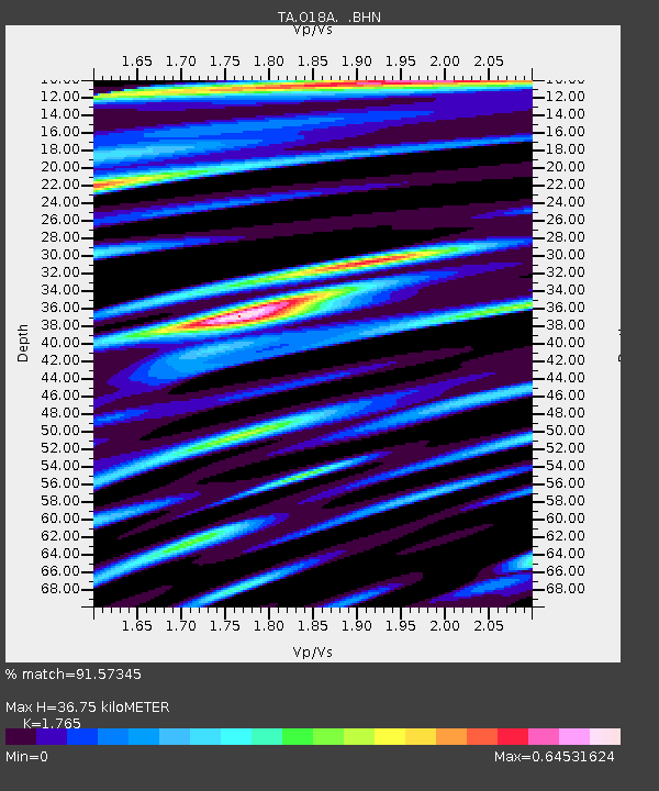
O18A Roosevelt, UT, USA - Earthquake Result Viewer

Earthquake location: Off East Coast Of Honshu, Japan
Earthquake latitude/longitude: 37.6/142.2
Earthquake time(UTC): 2008/07/19 (201) 02:39:28 GMT
Earthquake Depth: 22 km
Earthquake Magnitude: 6.2 MB, 7.0 MS, 7.0 MW, 6.9 MW
Earthquake Catalog/Contributor: WHDF/NEIC
Network: TA USArray Transportable Network (new EarthScope stations)
Station: O18A Roosevelt, UT, USA
Lat/Lon: 40.27 N/110.01 W
Elevation: 1582 m
Distance: 78.2 deg
Az: 48.114 deg
Baz: 309.353 deg
Ray Param: 0.04980258
Estimated Moho Depth: 36.75 km
Estimated Crust Vp/Vs: 1.76
Assumed Crust Vp: 6.155 km/s
Estimated Crust Vs: 3.487 km/s
Estimated Crust Poisson's Ratio: 0.26
Radial Match: 91.57345 %
Radial Bump: 400
Transverse Match: 81.46827 %
Transverse Bump: 400
SOD ConfigId: 2504
Insert Time: 2010-03-06 16:33:06.401 +0000
GWidth: 2.5
Max Bumps: 400
Tol: 0.001

Signal To Noise

ChannelStoNSTALTA
TA:O18A: :BHN:20080719T02:50:54.874011Z3.56490045.7707797E-71.6187772E-7
TA:O18A: :BHE:20080719T02:50:54.874011Z1.6886881.7572275E-71.0405873E-7
TA:O18A: :BHZ:20080719T02:50:54.874011Z1.96308281.2769064E-76.504598E-8
Arrivals
Ps4.7 SECOND
PpPs16 SECOND
PsPs/PpSs21 SECOND