You are here: Home > Network List > TA - USArray Transportable Network (new EarthScope stations) Stations List
> Station O18A Roosevelt, UT, USA > Earthquake Result Viewer
O18A Roosevelt, UT, USA - Earthquake Result Viewer

| Earthquake location: |
Kuril Islands |
| Earthquake latitude/longitude: |
49.9/156.4 |
| Earthquake time(UTC): |
2008/08/04 (217) 04:42:14 GMT |
| Earthquake Depth: |
77 km |
| Earthquake Magnitude: |
5.6 MB, 5.8 MW, 5.7 MW |
| Earthquake Catalog/Contributor: |
WHDF/NEIC |
|
| Network: |
TA USArray Transportable Network (new EarthScope stations) |
| Station: |
O18A Roosevelt, UT, USA |
| Lat/Lon: |
40.27 N/110.01 W |
| Elevation: |
1582 m |
|
| Distance: |
62.6 deg |
| Az: |
59.298 deg |
| Baz: |
313.335 deg |
| Ray Param: |
0.059895787 |
| Estimated Moho Depth: |
16.25 km |
| Estimated Crust Vp/Vs: |
1.85 |
| Assumed Crust Vp: |
6.155 km/s |
| Estimated Crust Vs: |
3.327 km/s |
| Estimated Crust Poisson's Ratio: |
0.29 |
|
| Radial Match: |
83.02899 % |
| Radial Bump: |
400 |
| Transverse Match: |
77.988 % |
| Transverse Bump: |
400 |
| SOD ConfigId: |
2504 |
| Insert Time: |
2010-03-06 16:33:10.775 +0000 |
| GWidth: |
2.5 |
| Max Bumps: |
400 |
| Tol: |
0.001 |
|
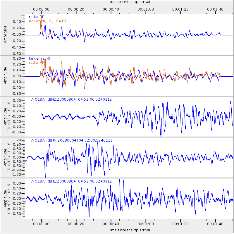
Signal To Noise
| Channel | StoN | STA | LTA |
| TA:O18A: :BHN:20080804T04:52:00.524011Z | 5.0020294 | 5.3490203E-7 | 1.06937E-7 |
| TA:O18A: :BHE:20080804T04:52:00.524011Z | 1.237437 | 8.712331E-8 | 7.040626E-8 |
| TA:O18A: :BHZ:20080804T04:52:00.524011Z | 2.5764673 | 1.3826276E-7 | 5.3663697E-8 |
| Arrivals |
| Ps | 2.3 SECOND |
| PpPs | 7.2 SECOND |
| PsPs/PpSs | 9.6 SECOND |


