You are here: Home > Network List > TA - USArray Transportable Network (new EarthScope stations) Stations List
> Station O18A Roosevelt, UT, USA > Earthquake Result Viewer
O18A Roosevelt, UT, USA - Earthquake Result Viewer
| Earthquake location: |
Kermadec Islands Region |
| Earthquake latitude/longitude: |
-27.4/-176.3 |
| Earthquake time(UTC): |
2009/02/18 (049) 21:53:45 GMT |
| Earthquake Depth: |
25 km |
| Earthquake Magnitude: |
6.8 MB, 7.2 MS, 6.9 MW, 6.9 MW |
| Earthquake Catalog/Contributor: |
WHDF/NEIC |
|
| Network: |
TA USArray Transportable Network (new EarthScope stations) |
| Station: |
O18A Roosevelt, UT, USA |
| Lat/Lon: |
40.27 N/110.01 W |
| Elevation: |
1582 m |
|
| Distance: |
91.2 deg |
| Az: |
44.503 deg |
| Baz: |
234.513 deg |
| Ray Param: |
0.04161303 |
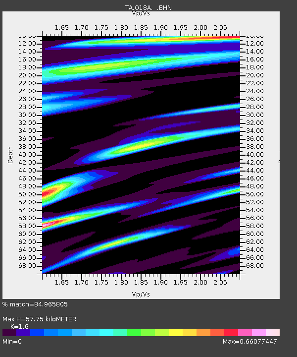
| Estimated Moho Depth: |
57.75 km |
| Estimated Crust Vp/Vs: |
1.60 |
| Assumed Crust Vp: |
6.155 km/s |
| Estimated Crust Vs: |
3.847 km/s |
| Estimated Crust Poisson's Ratio: |
0.18 |
|
| Radial Match: |
84.965805 % |
| Radial Bump: |
400 |
| Transverse Match: |
73.625946 % |
| Transverse Bump: |
400 |
| SOD ConfigId: |
2658 |
| Insert Time: |
2010-03-06 16:33:21.240 +0000 |
| GWidth: |
2.5 |
| Max Bumps: |
400 |
| Tol: |
0.001 |
|
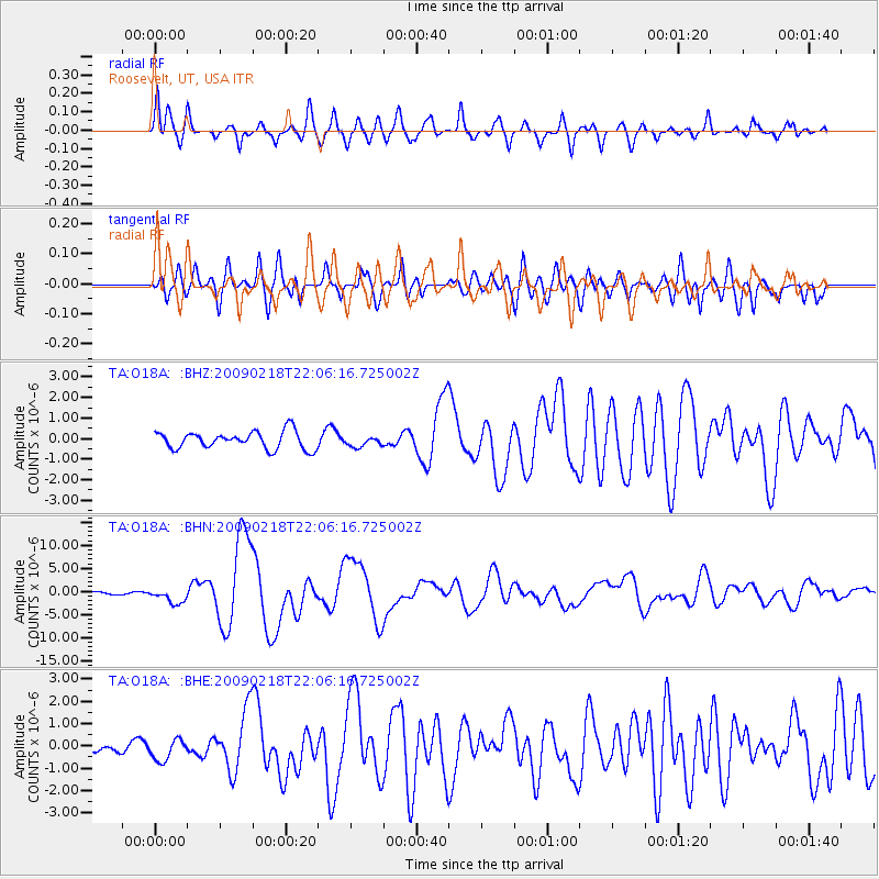
Signal To Noise
| Channel | StoN | STA | LTA |
| TA:O18A: :BHN:20090218T22:06:16.725002Z | 3.8625283 | 1.6193683E-6 | 4.1925085E-7 |
| TA:O18A: :BHE:20090218T22:06:16.725002Z | 1.4653853 | 4.634037E-7 | 3.1623333E-7 |
| TA:O18A: :BHZ:20090218T22:06:16.725002Z | 0.57475233 | 2.4176754E-7 | 4.2064647E-7 |
| Arrivals |
| Ps | 5.7 SECOND |
| PpPs | 24 SECOND |
| PsPs/PpSs | 30 SECOND |


