You are here: Home > Network List > TA - USArray Transportable Network (new EarthScope stations) Stations List
> Station O18A Roosevelt, UT, USA > Earthquake Result Viewer
O18A Roosevelt, UT, USA - Earthquake Result Viewer
| Earthquake location: |
Vanuatu Islands |
| Earthquake latitude/longitude: |
-15.6/167.7 |
| Earthquake time(UTC): |
2007/08/01 (213) 17:08:51 GMT |
| Earthquake Depth: |
120 km |
| Earthquake Magnitude: |
6.2 MB, 7.2 MW, 7.2 MW |
| Earthquake Catalog/Contributor: |
WHDF/NEIC |
|
| Network: |
TA USArray Transportable Network (new EarthScope stations) |
| Station: |
O18A Roosevelt, UT, USA |
| Lat/Lon: |
40.27 N/110.01 W |
| Elevation: |
1582 m |
|
| Distance: |
94.2 deg |
| Az: |
49.496 deg |
| Baz: |
253.249 deg |
| Ray Param: |
0.04101946 |
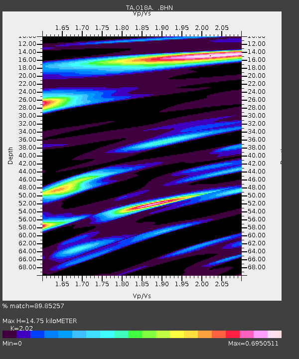
| Estimated Moho Depth: |
14.75 km |
| Estimated Crust Vp/Vs: |
2.02 |
| Assumed Crust Vp: |
6.155 km/s |
| Estimated Crust Vs: |
3.047 km/s |
| Estimated Crust Poisson's Ratio: |
0.34 |
|
| Radial Match: |
89.85257 % |
| Radial Bump: |
400 |
| Transverse Match: |
83.3097 % |
| Transverse Bump: |
400 |
| SOD ConfigId: |
2564 |
| Insert Time: |
2010-03-06 16:33:40.178 +0000 |
| GWidth: |
2.5 |
| Max Bumps: |
400 |
| Tol: |
0.001 |
|
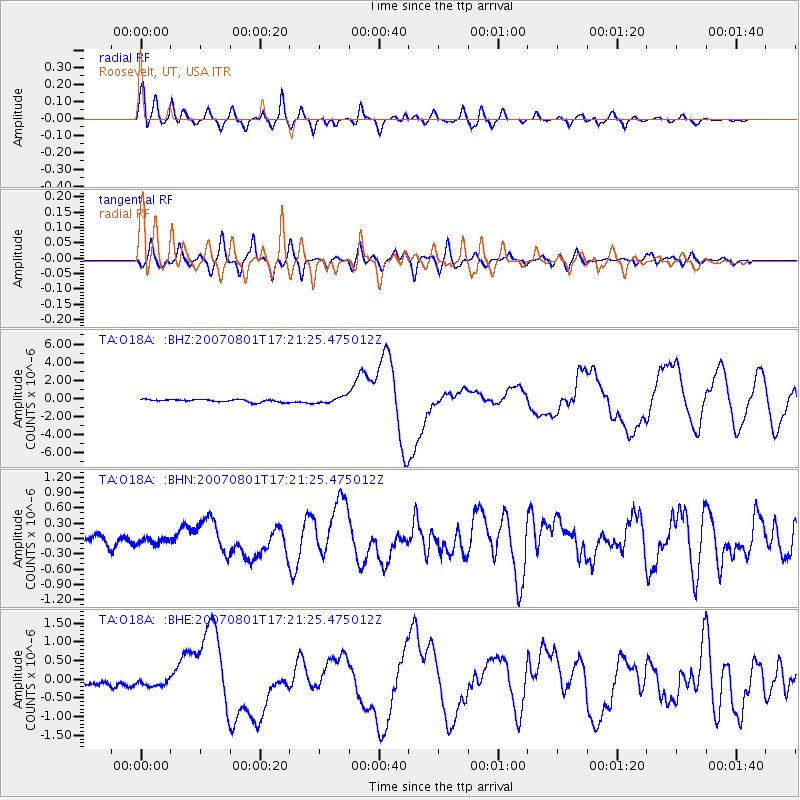
Signal To Noise
| Channel | StoN | STA | LTA |
| TA:O18A: :BHN:20070801T17:21:25.475012Z | 0.85261446 | 6.774772E-8 | 7.945879E-8 |
| TA:O18A: :BHE:20070801T17:21:25.475012Z | 1.2085372 | 8.801356E-8 | 7.2826516E-8 |
| TA:O18A: :BHZ:20070801T17:21:25.475012Z | 2.4716508 | 3.6315615E-7 | 1.4692857E-7 |
| Arrivals |
| Ps | 2.5 SECOND |
| PpPs | 7.1 SECOND |
| PsPs/PpSs | 9.6 SECOND |


