You are here: Home > Network List > TA - USArray Transportable Network (new EarthScope stations) Stations List
> Station O18A Roosevelt, UT, USA > Earthquake Result Viewer
O18A Roosevelt, UT, USA - Earthquake Result Viewer
| Earthquake location: |
South Of Panama |
| Earthquake latitude/longitude: |
5.7/-82.8 |
| Earthquake time(UTC): |
2009/03/12 (071) 23:23:34 GMT |
| Earthquake Depth: |
9.0 km |
| Earthquake Magnitude: |
6.1 MB, 5.9 MS, 6.3 MW, 6.2 MW |
| Earthquake Catalog/Contributor: |
WHDF/NEIC |
|
| Network: |
TA USArray Transportable Network (new EarthScope stations) |
| Station: |
O18A Roosevelt, UT, USA |
| Lat/Lon: |
40.27 N/110.01 W |
| Elevation: |
1582 m |
|
| Distance: |
42.2 deg |
| Az: |
328.596 deg |
| Baz: |
137.339 deg |
| Ray Param: |
0.07329331 |
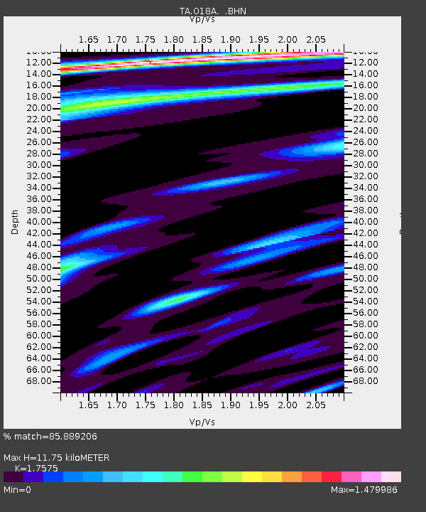
| Estimated Moho Depth: |
11.75 km |
| Estimated Crust Vp/Vs: |
1.76 |
| Assumed Crust Vp: |
6.155 km/s |
| Estimated Crust Vs: |
3.502 km/s |
| Estimated Crust Poisson's Ratio: |
0.26 |
|
| Radial Match: |
85.889206 % |
| Radial Bump: |
321 |
| Transverse Match: |
71.08446 % |
| Transverse Bump: |
399 |
| SOD ConfigId: |
2658 |
| Insert Time: |
2010-03-06 16:33:42.048 +0000 |
| GWidth: |
2.5 |
| Max Bumps: |
400 |
| Tol: |
0.001 |
|
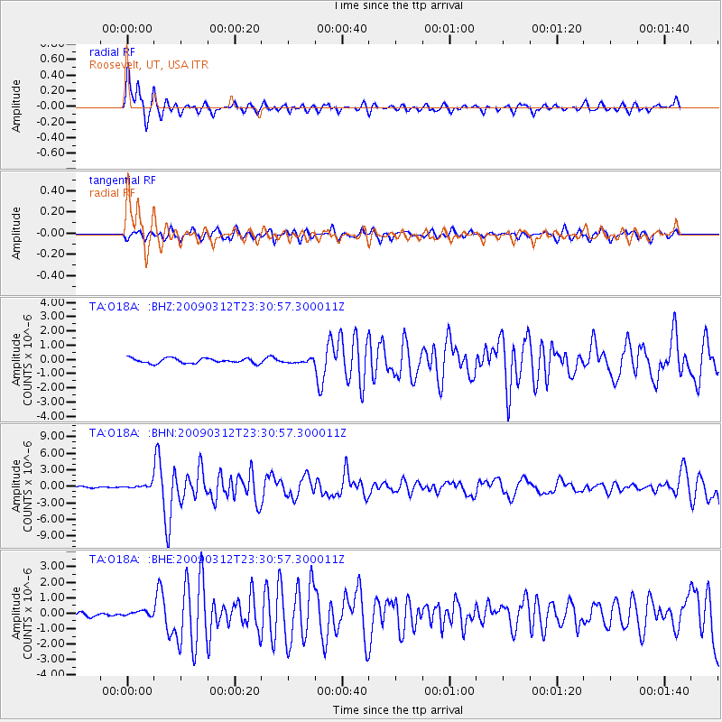
Signal To Noise
| Channel | StoN | STA | LTA |
| TA:O18A: :BHN:20090312T23:30:57.300011Z | 3.1559062 | 4.3388357E-7 | 1.3748303E-7 |
| TA:O18A: :BHE:20090312T23:30:57.300011Z | 1.1930143 | 1.7155168E-7 | 1.4379684E-7 |
| TA:O18A: :BHZ:20090312T23:30:57.300011Z | 0.6740261 | 1.1477622E-7 | 1.7028454E-7 |
| Arrivals |
| Ps | 1.5 SECOND |
| PpPs | 4.9 SECOND |
| PsPs/PpSs | 6.5 SECOND |


