You are here: Home > Network List > TA - USArray Transportable Network (new EarthScope stations) Stations List
> Station C23K Itkillik River, AK, USA > Earthquake Result Viewer
C23K Itkillik River, AK, USA - Earthquake Result Viewer
| Earthquake location: |
Kuril Islands |
| Earthquake latitude/longitude: |
49.4/156.2 |
| Earthquake time(UTC): |
2018/10/09 (282) 07:45:14 GMT |
| Earthquake Depth: |
42 km |
| Earthquake Magnitude: |
6.0 Mww |
| Earthquake Catalog/Contributor: |
NEIC PDE/us |
|
| Network: |
TA USArray Transportable Network (new EarthScope stations) |
| Station: |
C23K Itkillik River, AK, USA |
| Lat/Lon: |
69.84 N/150.61 W |
| Elevation: |
179 m |
|
| Distance: |
32.2 deg |
| Az: |
31.392 deg |
| Baz: |
258.747 deg |
| Ray Param: |
0.078668214 |
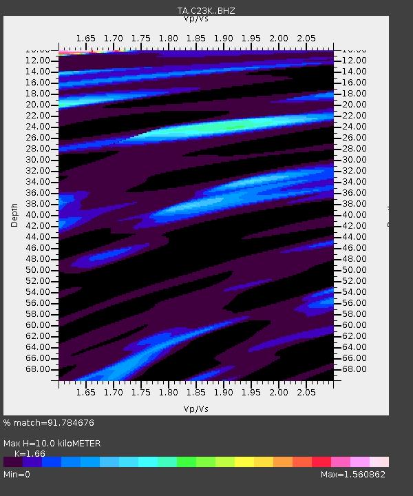
| Estimated Moho Depth: |
10.0 km |
| Estimated Crust Vp/Vs: |
1.66 |
| Assumed Crust Vp: |
6.221 km/s |
| Estimated Crust Vs: |
3.748 km/s |
| Estimated Crust Poisson's Ratio: |
0.22 |
|
| Radial Match: |
91.784676 % |
| Radial Bump: |
367 |
| Transverse Match: |
77.25673 % |
| Transverse Bump: |
400 |
| SOD ConfigId: |
13570011 |
| Insert Time: |
2019-05-01 10:48:48.495 +0000 |
| GWidth: |
2.5 |
| Max Bumps: |
400 |
| Tol: |
0.001 |
|

Signal To Noise
| Channel | StoN | STA | LTA |
| TA:C23K: :BHZ:20181009T07:51:08.025011Z | 8.308974 | 1.7929298E-6 | 2.1578232E-7 |
| TA:C23K: :BHN:20181009T07:51:08.025011Z | 2.0621128 | 3.9758615E-7 | 1.9280523E-7 |
| TA:C23K: :BHE:20181009T07:51:08.025011Z | 4.0204625 | 8.5051784E-7 | 2.1154727E-7 |
| Arrivals |
| Ps | 1.1 SECOND |
| PpPs | 4.0 SECOND |
| PsPs/PpSs | 5.1 SECOND |


