You are here: Home > Network List > TA - USArray Transportable Network (new EarthScope stations) Stations List
> Station E24K Your Creek, AK, USA > Earthquake Result Viewer
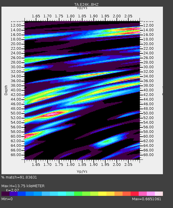
E24K Your Creek, AK, USA - Earthquake Result Viewer
| Earthquake location: |
Kuril Islands |
| Earthquake latitude/longitude: |
49.4/156.2 |
| Earthquake time(UTC): |
2018/10/09 (282) 07:45:14 GMT |
| Earthquake Depth: |
42 km |
| Earthquake Magnitude: |
6.0 Mww |
| Earthquake Catalog/Contributor: |
NEIC PDE/us |
|
| Network: |
TA USArray Transportable Network (new EarthScope stations) |
| Station: |
E24K Your Creek, AK, USA |
| Lat/Lon: |
68.07 N/148.49 W |
| Elevation: |
847 m |
|
| Distance: |
32.7 deg |
| Az: |
34.869 deg |
| Baz: |
263.664 deg |
| Ray Param: |
0.07846079 |
| Estimated Moho Depth: |
13.75 km |
| Estimated Crust Vp/Vs: |
2.07 |
| Assumed Crust Vp: |
6.316 km/s |
| Estimated Crust Vs: |
3.051 km/s |
| Estimated Crust Poisson's Ratio: |
0.35 |
|
| Radial Match: |
91.83631 % |
| Radial Bump: |
398 |
| Transverse Match: |
85.44347 % |
| Transverse Bump: |
400 |
| SOD ConfigId: |
13570011 |
| Insert Time: |
2019-05-01 10:49:00.252 +0000 |
| GWidth: |
2.5 |
| Max Bumps: |
400 |
| Tol: |
0.001 |
|

Signal To Noise
| Channel | StoN | STA | LTA |
| TA:E24K: :BHZ:20181009T07:51:12.249987Z | 19.704796 | 9.987722E-7 | 5.0686754E-8 |
| TA:E24K: :BHN:20181009T07:51:12.249987Z | 3.824685 | 1.8135447E-7 | 4.7416833E-8 |
| TA:E24K: :BHE:20181009T07:51:12.249987Z | 6.85444 | 4.4931778E-7 | 6.555134E-8 |
| Arrivals |
| Ps | 2.5 SECOND |
| PpPs | 6.3 SECOND |
| PsPs/PpSs | 8.8 SECOND |


